Weather Alerts for Montana
1. Lake Wind Advisory for: Central and Southeast Phillips; Central and Southern Valley; Petroleum; Garfield; McCone
2. Winter Storm Warning for: Absaroka/Beartooth Mountains; Crazy Mountains
3. Winter Storm Warning for: Little Belt and Highwood Mountains; Gallatin and Madison County Mountains and Centennial Mountains
4. Winter Storm Warning for: Pryor/Northern Bighorn Mountains; Northeast Bighorn Mountains
5. Winter Storm Warning for: Southern Big Horn; Bighorn Canyon; Sheridan Foothills
6. Winter Storm Warning for: Southern Rosebud
7. Winter Storm Watch for: Custer; Fallon; Powder River; Carter
8. Winter Storm Watch for: Dawson; Prairie; Wibaux
9. Winter Weather Advisory for: Big Belt, Bridger and Castle Mountains
10. Winter Weather Advisory for: Butte/Blackfoot Region
11. Winter Weather Advisory for: Cascade County below 5000ft; Judith Basin County and Judith Gap; Fergus County below 4500ft; Snowy and Judith Mountains
12. Winter Weather Advisory for: East Glacier Park Region; Southern Rocky Mountain Front; Upper Blackfoot and MacDonald Pass; Elkhorn and Boulder Mountains; Northwest Beaverhead County
13. Winter Weather Advisory for: Potomac/Seeley Lake Region
14. Winter Weather Advisory for: Ruby Mountains and Southern Beaverhead Mountains
15. Winter Weather Advisory for: Treasure; Northern Rosebud; Northern Big Horn; Northeastern Yellowstone; Southwestern Yellowstone
16. Winter Weather Advisory for: West Glacier Region
Want more detail? Get the Complete 7 Day and Night Detailed Forecast!
Current U.S. National Radar--Current
The Current National Weather Radar is shown below with a UTC Time (subtract 5 hours from UTC to get Eastern Time).

National Weather Forecast--Current
The Current National Weather Forecast and National Weather Map are shown below.

National Weather Forecast for Tomorrow
Tomorrow National Weather Forecast and Tomorrow National Weather Map are show below.

North America Water Vapor (Moisture)
This map shows recent moisture content over North America. Bright and colored areas show high moisture (ie, clouds); brown indicates very little moisture present; black indicates no moisture.

Weather Topic: What is Sleet?
Home - Education - Precipitation - Sleet
 Next Topic: Snow
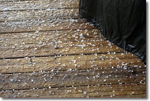
Sleet is a form of precipitation in which small ice pellets are the primary
components. These ice pellets are smaller and more translucent than hailstones,
and harder than graupel. Sleet is caused by specific atmospheric conditions and
therefore typically doesn't last for extended periods of time.
The condition which leads to sleet formation requires a warmer body of air to be
wedged in between two sub-freezing bodies of air. When snow falls through a warmer
layer of air it melts, and as it falls through the next sub-freezing body of air
it freezes again, forming ice pellets known as sleet. In some cases, water
droplets don't have time to freeze before reaching the surface and the result is
freezing rain.
Next Topic: Snow
Weather Topic: What are Stratocumulus Clouds?
Home - Education - Cloud Types - Stratocumulus Clouds
 Next Topic: Stratus Clouds
Stratocumulus clouds are similar to altocumulus clouds in their
fluffy appearance, but have a slightly darker shade due to their additional mass.
A good way to distinguish the two cloud types is to hold your hand out and measure
the size of an individual cloud; if it is the size of your thumb it is generally
an altocumulus cloud, if it is the size of your hand it is generally a
stratocumulus cloud.
It is uncommon for stratocumulus clouds to produce precipitation, but if they do
it is usually a light rain or snow.
Next Topic: Stratus Clouds
Current conditions powered by WeatherAPI.com


