Weather Alerts for Colorado
1. Air Quality Alert for: Garfield, CO; Eagle, CO
2. Air Quality Alert for: Montezuma, CO; Dolores, CO
3. Flood Advisory for: Delta, CO; Montrose, CO
4. Flood Advisory for: Garfield, CO; Mesa, CO
5. Flood Advisory for: Garfield, CO; Rio Blanco, CO
6. Flood Advisory for: La Plata, CO
7. Flood Advisory for: Mesa, CO
8. Flood Advisory for: Mesa, CO; Montrose, CO; San Juan, UT
9. Flood Advisory for: Moffat, CO
10. Flood Watch for: Northern Sangre de Cristo Mountains Between 8500 And 11000 Ft; Northern Sangre de Cristo Mountains above 11000 Ft; Southern Sangre De Cristo Mountains Between 7500 and 11000 Ft; Southern Sangre De Cristo Mountains Above 11000 Ft; Western/Central Fremont County Below 8500 Ft; Wet Mountain Valley Below 8500 Ft; Wet Mountains between 6300 and 10000Ft; Wet Mountains above 10000 Ft; Walsenburg Vicinity/Upper Huerfano River Basin Below 7500 Ft
11. Severe Thunderstorm Warning for: El Paso, CO
12. Severe Thunderstorm Warning for: Kit Carson, CO
13. Severe Thunderstorm Warning for: Lincoln, CO
14. Severe Thunderstorm Watch for: Cheyenne, CO; Kit Carson, CO
15. Severe Thunderstorm Watch for: Lincoln, CO
Want more detail? Get the Complete 7 Day and Night Detailed Forecast!
Current U.S. National Radar--Current
The Current National Weather Radar is shown below with a UTC Time (subtract 5 hours from UTC to get Eastern Time).

National Weather Forecast--Current
The Current National Weather Forecast and National Weather Map are shown below.

National Weather Forecast for Tomorrow
Tomorrow National Weather Forecast and Tomorrow National Weather Map are show below.

North America Water Vapor (Moisture)
This map shows recent moisture content over North America. Bright and colored areas show high moisture (ie, clouds); brown indicates very little moisture present; black indicates no moisture.

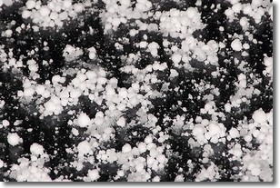
Weather Topic: What is Graupel?
Home - Education - Precipitation - Graupel
 Next Topic: Hail
Graupel is a form of precipitation that is created by atmospheric conditions
which cause supercooled water droplets to contact snow crystals and freeze to
their surface.
Sometimes known as soft hail or snow pellets, graupel is delicate and easily
destroyed by touch. Whereas hail usually falls during severe weather, graupel
doesn't require such conditions to form, and can form in mild precipitation
similar to situations which produce snowfall.
Next Topic: Hail
Weather Topic: What are Hole Punch Clouds?
Home - Education - Cloud Types - Hole Punch Clouds
 Next Topic: Mammatus Clouds
A hole punch cloud is an unusual occurrence when a disk-shaped
hole appears in a cirrostratus, cirrocumulus, or altocumulus cloud.
When part of the cloud forms ice crystals, water droplets in the surrounding area
of the cloud evaporate. The effect of this process produces a large elliptical
gap in the cloud. The hole punch cloud formation is rare, but it is not specific
to any geographic area.
Other names which have been used to describe this phenomena include fallstreak hole,
skypunch, and cloud hole.
Next Topic: Mammatus Clouds
Current conditions powered by WeatherAPI.com


