Weather Alerts for California
1. High Wind Warning for: Lassen-Eastern Plumas-Eastern Sierra Counties
2. High Wind Warning for: Mono
3. High Wind Watch for: Grapevine; Mojave Desert Slopes
4. Wind Advisory for: Coastal Del Norte; Del Norte Interior
5. Wind Advisory for: Indian Wells Valley; Mojave Desert
6. Wind Advisory for: Modoc County
7. Wind Advisory for: Owens Valley; Death Valley National Park; Eastern Mojave Desert, Including the Mojave National Preserve
8. Wind Advisory for: San Bernardino County Mountains; Riverside County Mountains; San Diego County Mountains; Apple and Lucerne Valleys; Coachella Valley; San Diego County Deserts; San Gorgonio Pass Near Banning
9. Wind Advisory for: Surprise Valley California; Northern Washoe County
10. Wind Advisory for: Western Mojave Desert
11. Winter Weather Advisory for: Greater Lake Tahoe Area; Greater Lake Tahoe Area
12. Winter Weather Advisory for: Modoc County
13. Winter Weather Advisory for: Mono
14. Winter Weather Advisory for: Northern Trinity
15. Winter Weather Advisory for: West Slope Northern Sierra Nevada
16. Winter Weather Advisory for: Western Siskiyou County
17. Winter Weather Advisory for: Yosemite NP outside of the valley; Upper San Joaquin River
Want more detail? Get the Complete 7 Day and Night Detailed Forecast!
Current U.S. National Radar--Current
The Current National Weather Radar is shown below with a UTC Time (subtract 5 hours from UTC to get Eastern Time).

National Weather Forecast--Current
The Current National Weather Forecast and National Weather Map are shown below.

National Weather Forecast for Tomorrow
Tomorrow National Weather Forecast and Tomorrow National Weather Map are show below.

North America Water Vapor (Moisture)
This map shows recent moisture content over North America. Bright and colored areas show high moisture (ie, clouds); brown indicates very little moisture present; black indicates no moisture.

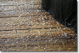
Weather Topic: What is Sleet?
Home - Education - Precipitation - Sleet
 Next Topic: Snow
Sleet is a form of precipitation in which small ice pellets are the primary
components. These ice pellets are smaller and more translucent than hailstones,
and harder than graupel. Sleet is caused by specific atmospheric conditions and
therefore typically doesn't last for extended periods of time.
The condition which leads to sleet formation requires a warmer body of air to be
wedged in between two sub-freezing bodies of air. When snow falls through a warmer
layer of air it melts, and as it falls through the next sub-freezing body of air
it freezes again, forming ice pellets known as sleet. In some cases, water
droplets don't have time to freeze before reaching the surface and the result is
freezing rain.
Next Topic: Snow
Weather Topic: What are Stratocumulus Clouds?
Home - Education - Cloud Types - Stratocumulus Clouds
 Next Topic: Stratus Clouds
Stratocumulus clouds are similar to altocumulus clouds in their
fluffy appearance, but have a slightly darker shade due to their additional mass.
A good way to distinguish the two cloud types is to hold your hand out and measure
the size of an individual cloud; if it is the size of your thumb it is generally
an altocumulus cloud, if it is the size of your hand it is generally a
stratocumulus cloud.
It is uncommon for stratocumulus clouds to produce precipitation, but if they do
it is usually a light rain or snow.
Next Topic: Stratus Clouds
Current conditions powered by WeatherAPI.com


