Weather Alert in California
Air Quality Alert issued September 4 at 8:01AM PDT by NWS Hanford CA
AREAS AFFECTED: Fresno, CA; Kern, CA; Kings, CA; Madera, CA; Merced, CA; San Joaquin, CA; Stanislaus, CA; Tulare, CA
DESCRIPTION: The Valley Air District is issuing an Air Quality Alert on September 3, 2025, due to smoke impacts from wildfires in California including the Garnet Fire, the Marmon Fire, the Salt 11-2 Fire, and the TCU September Lightning Complex for San Joaquin, Stanislaus, Merced, Madera, Fresno, Kings, Tulare, and the Valley portion of Kern Counties. This Air Quality Alert is in effect until the fires are extinguished. Exposure to particle pollution can cause serious health problems, aggravate lung disease, cause asthma attacks and acute bronchitis, and increase risk of respiratory infections. Residents are advised to use caution as conditions warrant. People with heart or lung diseases should follow their doctors advice for dealing with episodes of unhealthy air quality. Additionally, older adults and children should avoid prolonged exposure, strenuous activities or heavy exertion, as conditions dictate. For additional information, call your local San Joaquin Valley Air District office. Modesto 209-557-6400, Fresno 559-230-6000, Bakersfield 661-392-5500 Residents can also follow air quality conditions by downloading the free Valley Air app, available in the Apple store or Google Play, or by visiting the AirNow Fire and Smoke Map at fire.airnow.gov.
INSTRUCTION: N/A
Want more detail? Get the Complete 7 Day and Night Detailed Forecast!
Current U.S. National Radar--Current
The Current National Weather Radar is shown below with a UTC Time (subtract 5 hours from UTC to get Eastern Time).

National Weather Forecast--Current
The Current National Weather Forecast and National Weather Map are shown below.

National Weather Forecast for Tomorrow
Tomorrow National Weather Forecast and Tomorrow National Weather Map are show below.

North America Water Vapor (Moisture)
This map shows recent moisture content over North America. Bright and colored areas show high moisture (ie, clouds); brown indicates very little moisture present; black indicates no moisture.

Weather Topic: What is Drizzle?
Home - Education - Precipitation - Drizzle
 Next Topic: Evaporation
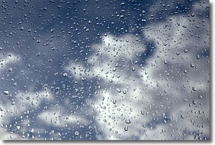
Drizzle is precipitation in the form of water droplets which are
smaller than raindrops.
Drizzle is characterized by fine, gently falling droplets and typically does not
impact human habitation in a negative way. The exception to this is freezing drizzle,
a condition where drizzle freezes immediately upon reaching earth's surface.
Freezing drizzle is still less dangerous than freezing rain, but can
potentially result in hazardous road conditions.
Next Topic: Evaporation
Weather Topic: What is Fog?
Home - Education - Cloud Types - Fog
 Next Topic: Fractus Clouds
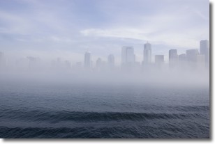
Fog is technically a type of stratus cloud, which lies along the
ground and obscures visibility.
It is usually created when humidity in the air condenses into tiny water droplets.
Because of this, some places are more prone to foggy weather, such as regions
close to a body of water.
Fog is similar to mist; both are the appearance of water droplets suspended in
the air, but fog is the term applied to the condition when visibility is less than 1 km.
Next Topic: Fractus Clouds
Current conditions powered by WeatherAPI.com


