Weather Alert in California
Flood Advisory issued February 10 at 8:33PM PST until February 10 at 11:30PM PST by NWS Los Angeles/Oxnard CA
AREAS AFFECTED: Santa Barbara, CA; Ventura, CA
DESCRIPTION: * WHAT...Flooding caused by excessive rainfall is expected. * WHERE...The eastern Santa Ynez Mountains to the western Ventura County mountains and foothills. * WHEN...Until 1130 PM PST. * IMPACTS...Minor flooding in low-lying and poor drainage areas. Rises in small streams and normally dry arroyos. * ADDITIONAL DETAILS... - At 829 PM PST, Doppler radar indicated heavy rain. Minor flooding is ongoing or expected to begin shortly in the advisory area. Between 0.5 and 1 inch of rain has fallen. - Additional rainfall amounts of 0.5 to 1 inch are expected over the area. This and additional rain will result in minor flooding in spots. - Some locations that will experience flooding include... Santa Barbara, Ojai, Montecito, Carpinteria, Summerland, Rose Valley, Lake Casitas, Highway 33 between Wheeler Springs and Rose Valley Road, Meiners Oaks, Solimar Beach, Mission Canyon, Highway 154 over San Marcos Pass and Santa Barbara Airport. - http://www.weather.gov/safety/flood
INSTRUCTION: Turn around, don't drown when encountering flooded roads. Most flood deaths occur in vehicles. Be especially cautious at night when it is harder to recognize the dangers of flooding. Flooding is occurring or is imminent. It is important to know where you are relative to streams, rivers, or creeks which can become killers in heavy rains. Campers and hikers should avoid streams or creeks.
Want more detail? Get the Complete 7 Day and Night Detailed Forecast!
Current U.S. National Radar--Current
The Current National Weather Radar is shown below with a UTC Time (subtract 5 hours from UTC to get Eastern Time).

National Weather Forecast--Current
The Current National Weather Forecast and National Weather Map are shown below.

National Weather Forecast for Tomorrow
Tomorrow National Weather Forecast and Tomorrow National Weather Map are show below.

North America Water Vapor (Moisture)
This map shows recent moisture content over North America. Bright and colored areas show high moisture (ie, clouds); brown indicates very little moisture present; black indicates no moisture.

Weather Topic: What is Drizzle?
Home - Education - Precipitation - Drizzle
 Next Topic: Evaporation
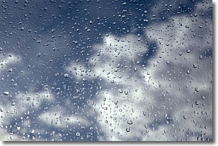
Drizzle is precipitation in the form of water droplets which are
smaller than raindrops.
Drizzle is characterized by fine, gently falling droplets and typically does not
impact human habitation in a negative way. The exception to this is freezing drizzle,
a condition where drizzle freezes immediately upon reaching earth's surface.
Freezing drizzle is still less dangerous than freezing rain, but can
potentially result in hazardous road conditions.
Next Topic: Evaporation
Weather Topic: What is Fog?
Home - Education - Cloud Types - Fog
 Next Topic: Fractus Clouds
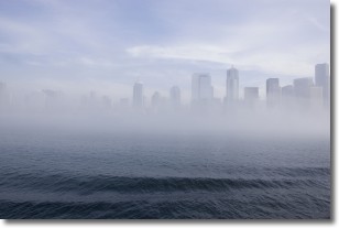
Fog is technically a type of stratus cloud, which lies along the
ground and obscures visibility.
It is usually created when humidity in the air condenses into tiny water droplets.
Because of this, some places are more prone to foggy weather, such as regions
close to a body of water.
Fog is similar to mist; both are the appearance of water droplets suspended in
the air, but fog is the term applied to the condition when visibility is less than 1 km.
Next Topic: Fractus Clouds
Current conditions powered by WeatherAPI.com


