Weather Alert in Oregon
Winter Storm Warning issued March 31 at 10:42AM PDT until April 2 at 5:00PM PDT by NWS Medford OR
AREAS AFFECTED: Eastern Douglas County Foothills; South Central Oregon Cascades; Siskiyou Mountains and Southern Oregon Cascades
DESCRIPTION: * WHAT...Heavy snow expected. Total snow accumulations 12 to 24 inches, with 24 to 30 inches in Crater Lake National Park. Winds gusting as high as 50 mph over high and exposed terrain. * WHERE...The southern Oregon Cascades north of Howard Prairie Lake, and the eastern Douglas County Foothills above 3000 ft, including the passes along highways 140, 62, 138, 230, and 58. * WHEN...From 5 AM Wednesday to 5 PM PDT Thursday. * IMPACTS...Travel may be very difficult to impossible. The hazardous conditions could impact the Wednesday morning and evening commutes. Gusty winds could bring down tree branches. * ADDITIONAL DETAILS...The heaviest snow is expected Wednesday afternoon when 1 in/hr rates are highly likely (>90% chance) and there is a 60-80% chance of 2 in/hr snowfall rates.
INSTRUCTION: If you must travel, keep an extra flashlight, food, and water in your vehicle in case of an emergency. Call 511 or visit tripcheck.com for road information.
Want more detail? Get the Complete 7 Day and Night Detailed Forecast!
Current U.S. National Radar--Current
The Current National Weather Radar is shown below with a UTC Time (subtract 5 hours from UTC to get Eastern Time).

National Weather Forecast--Current
The Current National Weather Forecast and National Weather Map are shown below.

National Weather Forecast for Tomorrow
Tomorrow National Weather Forecast and Tomorrow National Weather Map are show below.

North America Water Vapor (Moisture)
This map shows recent moisture content over North America. Bright and colored areas show high moisture (ie, clouds); brown indicates very little moisture present; black indicates no moisture.

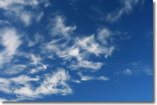
Weather Topic: What are Cirrostratus Clouds?
Home - Education - Cloud Types - Cirrostratus Clouds
 Next Topic: Cirrus Clouds
Cirrostratus clouds are high, thin clouds that form above
20,000 feet and are made mostly of ice crystals. They sometimes look like giant
feathers, horse tails, or curls of hair in the sky.
These clouds are pushed by the jet stream and can move at high speeds reaching
100 mph.
What do they indicate?
They indicate that a precipitation is likely within 24 hours.
Next Topic: Cirrus Clouds
Weather Topic: What is Condensation?
Home - Education - Precipitation - Condensation
 Next Topic: Contrails
Condensation is the process which creates clouds, and therefore
it is a crucial process in the water cycle.
Condensation is the change of matter from a state of gas into a state of liquid,
and it happens because water molecules release heat into the atmosphere and
become organized into a more closely packed structure, what we might see as
water droplets.
Water is always present in the air around us as a vapor, but it's too small for
us to see. When water undergoes the process of condensation it becomes organized
into visible water droplets. You've probably seen condensation happen before on the
surface of a cold drink!
Next Topic: Contrails
Current conditions powered by WeatherAPI.com


