Weather Alert in Montana
Winter Weather Advisory issued April 1 at 1:45PM MDT until April 3 at 6:00PM MDT by NWS Billings MT
AREAS AFFECTED: Treasure; Northern Rosebud; Northern Big Horn; Northeastern Yellowstone; Southwestern Yellowstone
DESCRIPTION: * WHAT...Periods of heavy snow. Total snow accumulations between 2 and 6 inches possible, greatest over the hills south of the Yellowstone River. Winds could gust as high as 35 mph. * WHERE...Northeastern Yellowstone, Northern Big Horn, Southwestern Yellowstone, Treasure, and Northern Rosebud. * WHEN...From 6 PM Thursday to 6 PM MDT Friday. * IMPACTS...Travel could be difficult due to snow, areas of blowing snow and poor visibility. This includes I-94 from Custer to Hysham and Forsyth. Cool, wet and breezy conditions will be hazardous for young livestock. * ADDITIONAL DETAILS...The heaviest snow is expected Thursday night into Friday morning.
INSTRUCTION: Slow down and use caution while traveling. For the latest road conditions, call 5 1 1.
Want more detail? Get the Complete 7 Day and Night Detailed Forecast!
Current U.S. National Radar--Current
The Current National Weather Radar is shown below with a UTC Time (subtract 5 hours from UTC to get Eastern Time).

National Weather Forecast--Current
The Current National Weather Forecast and National Weather Map are shown below.

National Weather Forecast for Tomorrow
Tomorrow National Weather Forecast and Tomorrow National Weather Map are show below.

North America Water Vapor (Moisture)
This map shows recent moisture content over North America. Bright and colored areas show high moisture (ie, clouds); brown indicates very little moisture present; black indicates no moisture.

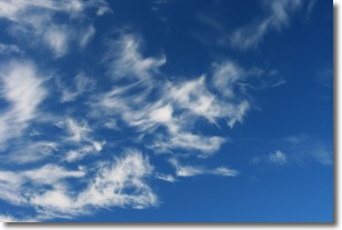
Weather Topic: What are Cirrostratus Clouds?
Home - Education - Cloud Types - Cirrostratus Clouds
 Next Topic: Cirrus Clouds
Cirrostratus clouds are high, thin clouds that form above
20,000 feet and are made mostly of ice crystals. They sometimes look like giant
feathers, horse tails, or curls of hair in the sky.
These clouds are pushed by the jet stream and can move at high speeds reaching
100 mph.
What do they indicate?
They indicate that a precipitation is likely within 24 hours.
Next Topic: Cirrus Clouds
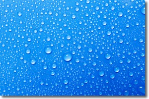
Weather Topic: What is Condensation?
Home - Education - Precipitation - Condensation
 Next Topic: Contrails
Condensation is the process which creates clouds, and therefore
it is a crucial process in the water cycle.
Condensation is the change of matter from a state of gas into a state of liquid,
and it happens because water molecules release heat into the atmosphere and
become organized into a more closely packed structure, what we might see as
water droplets.
Water is always present in the air around us as a vapor, but it's too small for
us to see. When water undergoes the process of condensation it becomes organized
into visible water droplets. You've probably seen condensation happen before on the
surface of a cold drink!
Next Topic: Contrails
Current conditions powered by WeatherAPI.com


