Weather Alert in Indiana
Flood Warning issued March 4 at 3:57AM EST until March 7 at 10:00AM EST by NWS Indianapolis IN
AREAS AFFECTED: Bartholomew, IN
DESCRIPTION: ...The National Weather Service in Indianapolis IN has issued a Flood Warning for the following rivers in Indiana... Big Blue River at Shelbyville. Driftwood River near Edinburgh. Flatrock River near Columbus. East Fork White River at Columbus. White River at Spencer. Eel River at Bowling Green. ...Forecast flooding changed from Minor to Moderate severity and increased in duration for the following rivers in Indiana... East Fork White River at Seymour. .Between 2 and 4 inches of rain have fallen across central Indiana as of early Wednesday morning. Up to 2 inches have fallen in south-central Indiana. This has led creeks to rise above flood stage and rivers will follow in the coming days. Additional rain is in the forecast over the next several days. * WHAT...Minor flooding is forecast. * WHERE...Flatrock River near Columbus. * WHEN...From late tonight to late Saturday morning. * IMPACTS...At 12.0 feet, On April 6, 2011 after reaching 13 feet... Noblitt Park...CR 400N and Owens Bend Park remained flooded. * ADDITIONAL DETAILS... - At 3:30 AM EST Wednesday the stage was 5.4 feet. - Forecast...The river is expected to rise above flood stage just after midnight tonight to a crest of 12.2 feet early Friday morning. It will then fall below flood stage early Saturday morning. - Flood stage is 11.0 feet. - http://www.weather.gov/safety/flood
INSTRUCTION: Motorists should not attempt to drive around barricades or drive cars through flooded areas. Additional information is available at www.weather.gov/ind. The next statement should be issued this evening by around 700 PM EST.
Want more detail? Get the Complete 7 Day and Night Detailed Forecast!
Current U.S. National Radar--Current
The Current National Weather Radar is shown below with a UTC Time (subtract 5 hours from UTC to get Eastern Time).

National Weather Forecast--Current
The Current National Weather Forecast and National Weather Map are shown below.

National Weather Forecast for Tomorrow
Tomorrow National Weather Forecast and Tomorrow National Weather Map are show below.

North America Water Vapor (Moisture)
This map shows recent moisture content over North America. Bright and colored areas show high moisture (ie, clouds); brown indicates very little moisture present; black indicates no moisture.

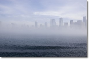
Weather Topic: What is Fog?
Home - Education - Cloud Types - Fog
 Next Topic: Fractus Clouds
Fog is technically a type of stratus cloud, which lies along the
ground and obscures visibility.
It is usually created when humidity in the air condenses into tiny water droplets.
Because of this, some places are more prone to foggy weather, such as regions
close to a body of water.
Fog is similar to mist; both are the appearance of water droplets suspended in
the air, but fog is the term applied to the condition when visibility is less than 1 km.
Next Topic: Fractus Clouds
Weather Topic: What is Freezing Rain?
Home - Education - Precipitation - Freezing Rain
 Next Topic: Graupel
Freezing rain is a condition where precipitation which has fallen in the form of
water droplets reaches temperatures which are below freezing and freezes upon
coming into contact
with surface objects. The result of this precipitation is a glaze of ice which
can be damaging to plants and man-made structures. A severe onset of freezing
rain which results in a very thick glaze of ice is known as an ice storm.
Next Topic: Graupel
Current conditions powered by WeatherAPI.com


