Weather Alert in North Carolina
Flood Advisory issued May 13 at 3:12PM EDT until May 13 at 5:00PM EDT by NWS Greenville-Spartanburg SC
AREAS AFFECTED: Cabarrus, NC
DESCRIPTION: * WHAT...Flooding caused by excessive runoff continues. * WHERE...A portion of piedmont North Carolina, including the following county, Cabarrus. * WHEN...Until 500 PM EDT. * IMPACTS...River or stream flows remain elevated. * ADDITIONAL DETAILS... - At 307 PM EDT, Localized excessive runoff continued to work through the Coddle Creek basin this afternoon. Please remain wary of elevated creek levels throughout the drainage. Watch for flooding of low-lying areas along Coddle Creek and especially Wolf Meadow Branch which was overtopping Stough Road. The streamgauge at Roberta Mill Road recently exceeded 12.5 feet, but was cresting, and stream levels should rapidly fall during the late afternoon hours. - Some locations that may experience flooding include... West Concord and Harrisburg. - http://www.weather.gov/safety/flood
INSTRUCTION: Be aware of your surroundings and do not drive on flooded roads!
Want more detail? Get the Complete 7 Day and Night Detailed Forecast!
Current U.S. National Radar--Current
The Current National Weather Radar is shown below with a UTC Time (subtract 5 hours from UTC to get Eastern Time).

National Weather Forecast--Current
The Current National Weather Forecast and National Weather Map are shown below.

National Weather Forecast for Tomorrow
Tomorrow National Weather Forecast and Tomorrow National Weather Map are show below.

North America Water Vapor (Moisture)
This map shows recent moisture content over North America. Bright and colored areas show high moisture (ie, clouds); brown indicates very little moisture present; black indicates no moisture.

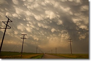
Weather Topic: What are Mammatus Clouds?
Home - Education - Cloud Types - Mammatus Clouds
 Next Topic: Nimbostratus Clouds
A mammatus cloud is a cloud with a unique feature which resembles
a web of pouches hanging along the base of the cloud.
In the United States, mammatus clouds tend to form in the warmer months, commonly
in the Midwest and eastern regions.
While they usually form at the bottom of a cumulonimbis cloud, they can also form
under altostratus, altocumulus, stratocumulus, and cirrus clouds. Mammatus clouds
warn that severe weather is close.
Next Topic: Nimbostratus Clouds
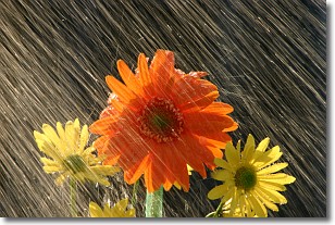
Weather Topic: What is Precipitation?
Home - Education - Precipitation - Precipitation
 Next Topic: Rain
Precipitation can refer to many different forms of water that
may fall from clouds. Precipitation occurs after a cloud has become saturated to
the point where its water particles are more dense than the air below the cloud.
In most cases, precipitation will reach the ground, but it is not uncommon for
precipitation to evaporate before it reaches the earth's surface.
When precipitation evaporates before it contacts the ground it is called Virga.
Graupel, hail, sleet, rain, drizzle, and snow are forms of precipitation, but fog
and mist are not considered precipitation because the water vapor which
constitutes them isn't dense enough to fall to the ground.
Next Topic: Rain
Current conditions powered by WeatherAPI.com


