Weather Alert in California
Air Quality Alert issued June 29 at 7:19PM PDT by NWS San Diego CA
AREAS AFFECTED: Riverside County Mountains; Coachella Valley; San Gorgonio Pass Near Banning
DESCRIPTION: * WHAT...The South Coast AQMD has issued an air quality alert due to increased fine particle pollution from wildfire smoke. * WHERE...The Banning Pass, San Jacinto Mountains, Lake Riverside area, Cahuilla Reservation, and Anza area. Levels of particle pollution can vary by time and location depending on fire activity and local weather conditions. * WHEN...Through 6 PM Monday. * IMPACTS...Particles in wildfire smoke can get deep into the lungs and cause serious health problems such as heart attacks, strokes, asthma attacks, and difficulty breathing. Everyone can be affected, but people with lung or heart disease, older adults, people who are pregnant, children, and those who spend a lot of time outdoors are at greater risk.
INSTRUCTION: To protect your health, if you smell or see smoke: * Remain indoors with windows and doors closed * Avoid intense outdoor physical activity * Run your air conditioner and/or an air purifier * If you must be outdoors, keep the time brief and wear a well- fitting N-95 mask * Do not use whole house fans or swamp coolers that bring in outside air if you have other methods to stay cool * Avoid other sources of pollution such as fireplaces, candles, incense, grilling, and gasoline-powered lawn and garden equipment * ADDITIONAL DETAILS... To view current and forecasted air quality levels, visit the South Coast Air Quality Management District website at aqmd.gov or download the mobile app at www.aqmd.gov/mobileapp. Additional details for this air quality alert may be available at www.aqmd.gov/advisory.
Want more detail? Get the Complete 7 Day and Night Detailed Forecast!
Current U.S. National Radar--Current
The Current National Weather Radar is shown below with a UTC Time (subtract 5 hours from UTC to get Eastern Time).

National Weather Forecast--Current
The Current National Weather Forecast and National Weather Map are shown below.

National Weather Forecast for Tomorrow
Tomorrow National Weather Forecast and Tomorrow National Weather Map are show below.

North America Water Vapor (Moisture)
This map shows recent moisture content over North America. Bright and colored areas show high moisture (ie, clouds); brown indicates very little moisture present; black indicates no moisture.

Weather Topic: What are Contrails?
Home - Education - Cloud Types - Contrails
 Next Topic: Cumulonimbus Clouds
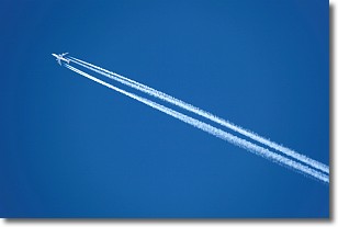
A contrail is an artificial cloud, created by the passing of an
aircraft.
Contrails form because water vapor in the exhaust of aircraft engines is suspended
in the air under certain temperatures and humidity conditions. These contrails
are called exhaust contrails.
Another type of contrail can form due to a temporary reduction in air pressure
moving over the plane's surface, causing condensation.
These are called aerodynamic contrails.
When you can see your breath on a cold day, it is also because of condensation.
The reason contrails last longer than the condensation from your breath is
because the water in contrails freezes into ice particles.
Next Topic: Cumulonimbus Clouds
Weather Topic: What are Cumulus Clouds?
Home - Education - Cloud Types - Cumulus Clouds
 Next Topic: Drizzle
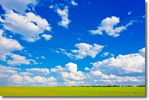
Cumulus clouds are fluffy and textured with rounded tops, and
may have flat bottoms. The border of a cumulus cloud
is clearly defined, and can have the appearance of cotton or cauliflower.
Cumulus clouds form at low altitudes (rarely above 2 km) but can grow very tall,
becoming cumulus congestus and possibly the even taller cumulonimbus clouds.
When cumulus clouds become taller, they have a greater chance of producing precipitation.
Next Topic: Drizzle
Current conditions powered by WeatherAPI.com


