Weather Alert in South Dakota
Red Flag Warning issued February 17 at 11:41AM MST until February 17 at 6:00PM MST by NWS Rapid City SD
AREAS AFFECTED: Central Black Hills; Southern Black Hills; Fall River County Area; Northern Foot Hills; Eastern Foot Hills; Custer County Plains; Pine Ridge Area; Butte County Area; West Central Plains; Haakon County Area; Badlands Area; Bennett County Area; Mellette and Todd Counties; Tripp County; Northern Campbell; Southern Campbell; Crook County Plains; Weston County Plains
DESCRIPTION: ...CRITICAL FIRE WEATHER CONDITIONS TUESDAY... Very dry air will continue to spread across the region Today, with relative humidities falling into the low teens to lower 20s. In addition, strong gusty westerly winds will continue with some areas seeing gusts over 60 mph, especially portions of northeast WY and far southwest SD. The combination of receptive fuels, strong gusty winds, and very low relative humidity are supportive of critical fire weather conditions. * AFFECTED AREA...Fire Weather Zones 314 Northern Campbell, 315 Southern Campbell, 316 Crook County Plains, 317 Weston County Plains, 320 Central Black Hills, 321 Southern Black Hills, 322 Fall River County Area, 323 Northern Foot Hills, 324 Eastern Foot Hills, 325 Custer County Plains, 326 Pine Ridge Area, 327 Butte County Area, 329 West Central Plains, 331 Haakon County Area, 332 Badlands Area, 333 Bennett County Area, 334 Mellette and Todd Counties and 335 Tripp County. * WINDS...West 25 to 35 mph with gusts up to 60 mph. * RELATIVE HUMIDITY...As low as 13 percent. * IMPACTS...The combination of gusty winds and low relative humidity will produce critical fire weather conditions.
INSTRUCTION: A Red Flag Warning means that critical fire weather conditions are either occurring now, or will shortly. A combination of strong winds, low relative humidity, and warm temperatures can contribute to extreme fire behavior.
Want more detail? Get the Complete 7 Day and Night Detailed Forecast!
Current U.S. National Radar--Current
The Current National Weather Radar is shown below with a UTC Time (subtract 5 hours from UTC to get Eastern Time).

National Weather Forecast--Current
The Current National Weather Forecast and National Weather Map are shown below.

National Weather Forecast for Tomorrow
Tomorrow National Weather Forecast and Tomorrow National Weather Map are show below.

North America Water Vapor (Moisture)
This map shows recent moisture content over North America. Bright and colored areas show high moisture (ie, clouds); brown indicates very little moisture present; black indicates no moisture.

Weather Topic: What are Fractus Clouds?
Home - Education - Cloud Types - Fractus Clouds
 Next Topic: Freezing Rain
A fractus cloud (scud) is a fragmented, tattered cloud which has
likely been sheared off of another cloud. They are accessory clouds, meaning they
develop from parent clouds, and are named in a way which describes the original
cloud which contained them.
Fractus clouds which have originated from cumulus clouds are referred to as
cumulus fractus, while fractus clouds which have originated from stratus clouds
are referred to as stratus fractus. Under certain conditions a fractus cloud might
merge with another cloud, or develop into a cumulus cloud, but usually a
fractus cloud seen by itself will dissipate rapidly.
They are often observed on the leading and trailing edges of storm clouds,
and are a display of wind activity.
Next Topic: Freezing Rain
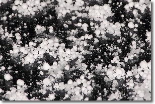
Weather Topic: What is Graupel?
Home - Education - Precipitation - Graupel
 Next Topic: Hail
Graupel is a form of precipitation that is created by atmospheric conditions
which cause supercooled water droplets to contact snow crystals and freeze to
their surface.
Sometimes known as soft hail or snow pellets, graupel is delicate and easily
destroyed by touch. Whereas hail usually falls during severe weather, graupel
doesn't require such conditions to form, and can form in mild precipitation
similar to situations which produce snowfall.
Next Topic: Hail
Current conditions powered by WeatherAPI.com


