Weather Alert in Maryland
Winter Weather Advisory issued February 10 at 8:08PM EST until February 11 at 3:00PM EST by NWS Baltimore MD/Washington DC
AREAS AFFECTED: Western Garrett; Western Grant; Western Pendleton
DESCRIPTION: * WHAT...Mixed precipitation expected. Total snow accumulations up to one inch and ice accumulations around a light glaze. Winds gusting as high as 45 mph. * WHERE...In Maryland, Western Garrett County. In West Virginia, Western Grant and Western Pendleton Counties. * WHEN...From 3 AM to 3 PM EST Wednesday. * IMPACTS...Plan on slippery road conditions. The hazardous conditions could impact the Wednesday morning commute. Gusty winds could bring down tree branches. * ADDITIONAL DETAILS...Occasional freezing drizzle may lead to slippery conditions late tonight through early Wednesday afternoon. Snow showers could continue at times Wednesday night and Thursday.
INSTRUCTION: Slow down and use caution while traveling. The latest road conditions for the state you are calling from can be obtained by calling 5 1 1.
Want more detail? Get the Complete 7 Day and Night Detailed Forecast!
Current U.S. National Radar--Current
The Current National Weather Radar is shown below with a UTC Time (subtract 5 hours from UTC to get Eastern Time).

National Weather Forecast--Current
The Current National Weather Forecast and National Weather Map are shown below.

National Weather Forecast for Tomorrow
Tomorrow National Weather Forecast and Tomorrow National Weather Map are show below.

North America Water Vapor (Moisture)
This map shows recent moisture content over North America. Bright and colored areas show high moisture (ie, clouds); brown indicates very little moisture present; black indicates no moisture.

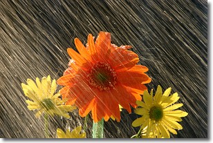
Weather Topic: What is Precipitation?
Home - Education - Precipitation - Precipitation
 Next Topic: Rain
Precipitation can refer to many different forms of water that
may fall from clouds. Precipitation occurs after a cloud has become saturated to
the point where its water particles are more dense than the air below the cloud.
In most cases, precipitation will reach the ground, but it is not uncommon for
precipitation to evaporate before it reaches the earth's surface.
When precipitation evaporates before it contacts the ground it is called Virga.
Graupel, hail, sleet, rain, drizzle, and snow are forms of precipitation, but fog
and mist are not considered precipitation because the water vapor which
constitutes them isn't dense enough to fall to the ground.
Next Topic: Rain
Weather Topic: What are Shelf Clouds?
Home - Education - Cloud Types - Shelf Clouds
 Next Topic: Sleet
A shelf cloud is similar to a wall cloud, but forms at the front
of a storm cloud, instead of at the rear, where wall clouds form.
A shelf cloud is caused by a series of events set into motion by the advancing
storm; first, cool air settles along the ground where precipitation has just fallen.
As the cool air is brought in, the warmer air is displaced, and rises above it,
because it is less dense. When the warmer air reaches the bottom of the storm cloud,
it begins to cool again, and the resulting condensation is a visible shelf cloud.
Next Topic: Sleet
Current conditions powered by WeatherAPI.com


