Weather Alert in Montana
Avalanche Warning issued February 25 at 8:24AM MST by NWS Missoula MT
AREAS AFFECTED: Potomac/Seeley Lake Region
DESCRIPTION: AVWMSO The following message is transmitted at the request of West Central Montana Avalanche Center Missoula MT. ...AVALANCHE WARNING ISSUED BY THE WEST CENTRAL MONTANA AVALANCHE CENTER... 07:30 MST Wed Feb 25 2026 The West Central Montana Avalanche Center in Missoula has issued a BACKCOUNTRY AVALANCHE WARNING for the following areas: NWS Missoula MT - MTZ043 (MTZ043) * WHAT...Several feet of new snow, coupled with strong ridgetop winds, have created dangerous avalanche conditions. This new snow will likely overload buried weak layers and lead to large natural avalanches. Travel in and below avalanche terrain is not recommended. * WHERE...The Seeley Lake mountains above 5500'. * WHEN...In effect from Wed 07:30 MST to Thu 04:00 MST. * IMPACTS...Natural and human-triggered avalanches are likely. Avalanches will release on weak layers buried two to four feet deep. It will be possible to remotely trigger avalanches from below, above, or to the side of steeper slopes. Avalanches may connect across terrain features, creating large and destructive avalanches. * PRECAUTIONARY / PREPAREDNESS ACTIONS...Dangerous avalanche conditions exist. Travel in avalanche terrain is not recommended. Avoid travel underneath steep slopes. Even small slopes like roadcuts and gullies have potential to deposit enough debris to bury or injure a person. Consult https://missoulaavalanche.org/ or www.avalanche.org for more detailed information. Similar avalanche danger may exist at locations outside the coverage area of this or any avalanche center.
INSTRUCTION: N/A
Want more detail? Get the Complete 7 Day and Night Detailed Forecast!
Current U.S. National Radar--Current
The Current National Weather Radar is shown below with a UTC Time (subtract 5 hours from UTC to get Eastern Time).

National Weather Forecast--Current
The Current National Weather Forecast and National Weather Map are shown below.

National Weather Forecast for Tomorrow
Tomorrow National Weather Forecast and Tomorrow National Weather Map are show below.

North America Water Vapor (Moisture)
This map shows recent moisture content over North America. Bright and colored areas show high moisture (ie, clouds); brown indicates very little moisture present; black indicates no moisture.

Weather Topic: What is Freezing Rain?
Home - Education - Precipitation - Freezing Rain
 Next Topic: Graupel
Freezing rain is a condition where precipitation which has fallen in the form of
water droplets reaches temperatures which are below freezing and freezes upon
coming into contact
with surface objects. The result of this precipitation is a glaze of ice which
can be damaging to plants and man-made structures. A severe onset of freezing
rain which results in a very thick glaze of ice is known as an ice storm.
Next Topic: Graupel
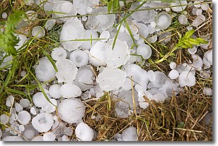
Weather Topic: What is Hail?
Home - Education - Precipitation - Hail
 Next Topic: Hole Punch Clouds
Hail is a form of precipitation which is recognized by large solid balls or
clumps of ice. Hail is created by thunderstorm clouds with strong updrafts of wind.
As the hailstones remain in the updraft, ice is deposited onto them until their
weight becomes heavy enough for them to fall to the earth's surface.
Hail storms can cause significant damage to crops, aircrafts, and man-made structures,
despite the fact that the duration is usually less than ten minutes.
Next Topic: Hole Punch Clouds
Current conditions powered by WeatherAPI.com


