Weather Alert in Arizona
Wind Advisory issued May 13 at 5:12AM MST until May 13 at 7:00PM MST by NWS Flagstaff AZ
AREAS AFFECTED: Kaibab Plateau; Marble and Glen Canyons; Grand Canyon Country; Coconino Plateau; Yavapai County Mountains; Northeast Plateaus and Mesas Hwy 264 Northward; Chinle Valley; Chuska Mountains and Defiance Plateau; Western Mogollon Rim; Eastern Mogollon Rim; White Mountains; Yavapai County Valleys and Basins; Oak Creek and Sycamore Canyons; Black Mesa Area; Northeast Plateaus and Mesas South of Hwy 264
DESCRIPTION: * WHAT...Southwest winds 25 to 35 mph with gusts 45 to 55 mph expected. * WHERE...Navajo Nation in Arizona, Mogollon Rim, Yavapai County, Kaibab Plateau, Marble and Glen Canyons, Grand Canyon Country, Coconino Plateau, White Mountains, and Oak Creek and Sycamore Canyons. * WHEN...From 8 AM MST /9 AM MDT/ this morning to 7 PM MST /8 PM MDT/ this evening. * IMPACTS...Travel will be difficult, especially for high profile vehicles. Patchy blowing dust will lead to reduced visibilities, resulting in hazardous driving conditions at times.
INSTRUCTION: Secure loose outdoor objects that could be blown around or damaged by the wind. Winds this strong can make driving difficult, especially for high profile vehicles, such as RVs, campers, and tractor trailers. Use extra caution.
Want more detail? Get the Complete 7 Day and Night Detailed Forecast!
Current U.S. National Radar--Current
The Current National Weather Radar is shown below with a UTC Time (subtract 5 hours from UTC to get Eastern Time).

National Weather Forecast--Current
The Current National Weather Forecast and National Weather Map are shown below.

National Weather Forecast for Tomorrow
Tomorrow National Weather Forecast and Tomorrow National Weather Map are show below.

North America Water Vapor (Moisture)
This map shows recent moisture content over North America. Bright and colored areas show high moisture (ie, clouds); brown indicates very little moisture present; black indicates no moisture.

Weather Topic: What are Altostratus Clouds?
Home - Education - Cloud Types - Altostratus Clouds
 Next Topic: Cirrocumulus Clouds
Altostratus clouds form at mid to high-level altitudes
(between 2 and 7 km) and are created by a warm, stable air mass which causes
water vapor
to condense as it rise through the atmosphere. Usually altostratus clouds are
featureless sheets characterized by a uniform color.
In some cases, wind punching through the cloud formation may give it a waved
appearance, called altostratus undulatus. Altostratus clouds
are commonly seen with other cloud formations accompanying them.
Next Topic: Cirrocumulus Clouds
Weather Topic: What are Cirrostratus Clouds?
Home - Education - Cloud Types - Cirrostratus Clouds
 Next Topic: Cirrus Clouds
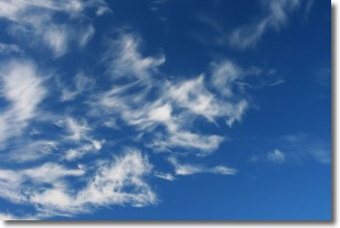
Cirrostratus clouds are high, thin clouds that form above
20,000 feet and are made mostly of ice crystals. They sometimes look like giant
feathers, horse tails, or curls of hair in the sky.
These clouds are pushed by the jet stream and can move at high speeds reaching
100 mph.
What do they indicate?
They indicate that a precipitation is likely within 24 hours.
Next Topic: Cirrus Clouds
Current conditions powered by WeatherAPI.com


