Weather Alert in Arizona
Flood Watch issued August 25 at 2:00AM MST until August 25 at 9:00PM MST by NWS Phoenix AZ
AREAS AFFECTED: Parker Valley; Kofa; Yuma; Central La Paz; Southeast Yuma County; Gila River Valley; Gila Bend; Sonoran Desert Natl Monument; Imperial County Southwest; Salton Sea; Chuckwalla Mountains; Imperial County Southeast; Imperial County West; Imperial Valley; Palo Verde Valley; Chuckwalla Valley
DESCRIPTION: * WHAT...Flash flooding caused by excessive rainfall is possible. * WHERE...Portions of Arizona, including the following areas, Central La Paz, Gila Bend, Gila River Valley, Kofa, Parker Valley, Sonoran Desert Natl Monument, Southeast Yuma County and Yuma and southeast California, including the following areas, Chuckwalla Mountains, Chuckwalla Valley, Imperial County Southeast, Imperial County Southwest, Imperial County West, Imperial Valley, Palo Verde Valley and Salton Sea. * WHEN...From 1 PM MST /1 PM PDT/ this afternoon through this evening. * IMPACTS...Excessive runoff may result in flooding of rivers, creeks, streams, and other low-lying and flood-prone locations. Flooding may occur in poor drainage and urban areas. Low-water crossings may be flooded. * ADDITIONAL DETAILS... - High atmospheric moisture content in combination with instability and slow moving showers and storms may result in heavy rainfall and flooding in the watch area. - http://www.weather.gov/safety/flood
INSTRUCTION: You should monitor later forecasts and be alert for possible Flood Warnings. Those living in areas prone to flooding should be prepared to take action should flooding develop.
Want more detail? Get the Complete 7 Day and Night Detailed Forecast!
Current U.S. National Radar--Current
The Current National Weather Radar is shown below with a UTC Time (subtract 5 hours from UTC to get Eastern Time).

National Weather Forecast--Current
The Current National Weather Forecast and National Weather Map are shown below.

National Weather Forecast for Tomorrow
Tomorrow National Weather Forecast and Tomorrow National Weather Map are show below.

North America Water Vapor (Moisture)
This map shows recent moisture content over North America. Bright and colored areas show high moisture (ie, clouds); brown indicates very little moisture present; black indicates no moisture.

Weather Topic: What is Drizzle?
Home - Education - Precipitation - Drizzle
 Next Topic: Evaporation
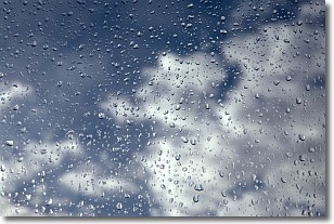
Drizzle is precipitation in the form of water droplets which are
smaller than raindrops.
Drizzle is characterized by fine, gently falling droplets and typically does not
impact human habitation in a negative way. The exception to this is freezing drizzle,
a condition where drizzle freezes immediately upon reaching earth's surface.
Freezing drizzle is still less dangerous than freezing rain, but can
potentially result in hazardous road conditions.
Next Topic: Evaporation
Weather Topic: What is Fog?
Home - Education - Cloud Types - Fog
 Next Topic: Fractus Clouds
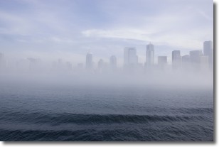
Fog is technically a type of stratus cloud, which lies along the
ground and obscures visibility.
It is usually created when humidity in the air condenses into tiny water droplets.
Because of this, some places are more prone to foggy weather, such as regions
close to a body of water.
Fog is similar to mist; both are the appearance of water droplets suspended in
the air, but fog is the term applied to the condition when visibility is less than 1 km.
Next Topic: Fractus Clouds
Current conditions powered by WeatherAPI.com


