Weather Alert in Arizona
Flash Flood Warning issued August 25 at 2:09PM MST until August 25 at 5:15PM MST by NWS Tucson AZ
AREAS AFFECTED: Santa Cruz, AZ
DESCRIPTION: FFWTWC The National Weather Service in Tucson has issued a * Flash Flood Warning for... South Central Santa Cruz County in southeastern Arizona... * Until 515 PM MST. * At 209 PM MST, gauge reports indicated thunderstorms producing heavy rain in Nogales. Between 0.8 and 1 inch of rain has fallen. Additional rainfall of 1 to 2 inches is expected within the next 3 hours. Flash flooding is ongoing or expected to begin shortly. HAZARD...Life threatening flash flooding. Thunderstorms producing flash flooding. SOURCE...Gauges reported. IMPACT...Life threatening flash flooding of creeks and streams, urban areas, highways, streets and underpasses. * Some locations that will experience flash flooding include... Nogales. This includes the following highways... Interstate 19 between mile markers 1 and 7. Route 82 between mile markers 1 and 5. This includes the following Flash Flood Prone Locations... Nogales Wash at Doe St Bridge.
INSTRUCTION: Turn around, don't drown when encountering flooded roads. Most flood deaths occur in vehicles.
Want more detail? Get the Complete 7 Day and Night Detailed Forecast!
Current U.S. National Radar--Current
The Current National Weather Radar is shown below with a UTC Time (subtract 5 hours from UTC to get Eastern Time).

National Weather Forecast--Current
The Current National Weather Forecast and National Weather Map are shown below.

National Weather Forecast for Tomorrow
Tomorrow National Weather Forecast and Tomorrow National Weather Map are show below.

North America Water Vapor (Moisture)
This map shows recent moisture content over North America. Bright and colored areas show high moisture (ie, clouds); brown indicates very little moisture present; black indicates no moisture.

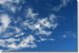
Weather Topic: What are Cirrostratus Clouds?
Home - Education - Cloud Types - Cirrostratus Clouds
 Next Topic: Cirrus Clouds
Cirrostratus clouds are high, thin clouds that form above
20,000 feet and are made mostly of ice crystals. They sometimes look like giant
feathers, horse tails, or curls of hair in the sky.
These clouds are pushed by the jet stream and can move at high speeds reaching
100 mph.
What do they indicate?
They indicate that a precipitation is likely within 24 hours.
Next Topic: Cirrus Clouds
Weather Topic: What is Condensation?
Home - Education - Precipitation - Condensation
 Next Topic: Contrails
Condensation is the process which creates clouds, and therefore
it is a crucial process in the water cycle.
Condensation is the change of matter from a state of gas into a state of liquid,
and it happens because water molecules release heat into the atmosphere and
become organized into a more closely packed structure, what we might see as
water droplets.
Water is always present in the air around us as a vapor, but it's too small for
us to see. When water undergoes the process of condensation it becomes organized
into visible water droplets. You've probably seen condensation happen before on the
surface of a cold drink!
Next Topic: Contrails
Current conditions powered by WeatherAPI.com


