Weather Alert in Colorado
Winter Storm Warning Winter Weather Advisory
Red Flag Warning issued February 18 at 11:36AM MST until February 19 at 7:00PM MST by NWS Pueblo CO
AREAS AFFECTED: Southern El Paso County Including Fort Carson and Colorado Springs; Pueblo County Including Pueblo; Western Las Animas County Including Trinidad and Thatcher
DESCRIPTION: The National Weather Service in Pueblo has issued a Red Flag Warning for gusty winds and low relative humidity, which is in effect from 10 AM to 7 PM MST Thursday. The Fire Weather Watch is no longer in effect. * AFFECTED AREA...Fire Weather Zones 227, 228 and 230. * TIMING...For the first Red Flag Warning, until 7 PM MST this evening. For the second Red Flag Warning, from 10 AM to 7 PM MST Thursday. * WINDS...West 30 to 40 mph with gusts up to 60 mph through this evening. West winds 15 to 25 mph with gusts up to 35 mph for Thursday. * RELATIVE HUMIDITY...As low as 11 percent. * IMPACTS...Fires will catch and spread quickly. Exercise extreme caution and avoid activities which could start a wildfire.
INSTRUCTION: A Red Flag Warning means that critical fire weather conditions are either occurring now, or will shortly. A combination of strong winds, low relative humidity, and warm temperatures can contribute to extreme fire behavior.
Want more detail? Get the Complete 7 Day and Night Detailed Forecast!
Current U.S. National Radar--Current
The Current National Weather Radar is shown below with a UTC Time (subtract 5 hours from UTC to get Eastern Time).

National Weather Forecast--Current
The Current National Weather Forecast and National Weather Map are shown below.

National Weather Forecast for Tomorrow
Tomorrow National Weather Forecast and Tomorrow National Weather Map are show below.

North America Water Vapor (Moisture)
This map shows recent moisture content over North America. Bright and colored areas show high moisture (ie, clouds); brown indicates very little moisture present; black indicates no moisture.

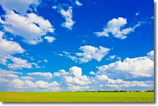
Weather Topic: What are Cumulus Clouds?
Home - Education - Cloud Types - Cumulus Clouds
 Next Topic: Drizzle
Cumulus clouds are fluffy and textured with rounded tops, and
may have flat bottoms. The border of a cumulus cloud
is clearly defined, and can have the appearance of cotton or cauliflower.
Cumulus clouds form at low altitudes (rarely above 2 km) but can grow very tall,
becoming cumulus congestus and possibly the even taller cumulonimbus clouds.
When cumulus clouds become taller, they have a greater chance of producing precipitation.
Next Topic: Drizzle
Weather Topic: What is Evaporation?
Home - Education - Precipitation - Evaporation
 Next Topic: Fog
Evaporation is the process which returns water from the earth
back to the atmosphere, and is another crucial process in the water cycle.
Evaporation is the transformation of liquid into gas, and it happens because
molecules are excited by the application of energy and turn into vapor.
In order for water to evaporate it has to be on the surface of a body of water.
Next Topic: Fog
Current conditions powered by WeatherAPI.com


