Weather Alert in Hawaii
High Surf Advisory issued February 10 at 3:12PM HST until February 11 at 6:00AM HST by NWS Honolulu HI
AREAS AFFECTED: Olomana; Kahoolawe; Maui Windward West; Kauai East; East Honolulu; Koolau Windward; Molokai Windward; Molokai Southeast; Windward Haleakala; Kipahulu; South Haleakala; Big Island Southeast; Big Island East; Big Island North
DESCRIPTION: ...HIGH SURF ADVISORY IN EFFECT UNTIL 6 AM HST WEDNESDAY FOR EAST FACING SHORES OF KAUAI OAHU MOLOKAI MAUI KAHOOLAWE AND THE BIG ISLAND... .Strong to gale force easterly trade winds will produce high surf along east facing shores exposed to these stronger winds. Wind speeds will slowly decrease through Wednesday with surf heights falling just below advisory thresholds along the east facing shorelines by Wednesday morning. * WHAT...Large breaking waves of 7 to 10 feet. * WHERE...East facing shores of Kauai, Oahu, Molokai, Maui, Kahoolawe, and the Big Island. * WHEN...Until 6 AM HST Wednesday. * IMPACTS...Moderate. Strong breaking waves and strong currents will make swimming dangerous.
INSTRUCTION: Heed all advice from ocean safety officials. When in doubt, don't go out.
Want more detail? Get the Complete 7 Day and Night Detailed Forecast!
Current U.S. National Radar--Current
The Current National Weather Radar is shown below with a UTC Time (subtract 5 hours from UTC to get Eastern Time).

National Weather Forecast--Current
The Current National Weather Forecast and National Weather Map are shown below.

National Weather Forecast for Tomorrow
Tomorrow National Weather Forecast and Tomorrow National Weather Map are show below.

North America Water Vapor (Moisture)
This map shows recent moisture content over North America. Bright and colored areas show high moisture (ie, clouds); brown indicates very little moisture present; black indicates no moisture.

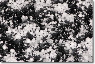
Weather Topic: What is Graupel?
Home - Education - Precipitation - Graupel
 Next Topic: Hail
Graupel is a form of precipitation that is created by atmospheric conditions
which cause supercooled water droplets to contact snow crystals and freeze to
their surface.
Sometimes known as soft hail or snow pellets, graupel is delicate and easily
destroyed by touch. Whereas hail usually falls during severe weather, graupel
doesn't require such conditions to form, and can form in mild precipitation
similar to situations which produce snowfall.
Next Topic: Hail
Weather Topic: What are Hole Punch Clouds?
Home - Education - Cloud Types - Hole Punch Clouds
 Next Topic: Mammatus Clouds
A hole punch cloud is an unusual occurrence when a disk-shaped
hole appears in a cirrostratus, cirrocumulus, or altocumulus cloud.
When part of the cloud forms ice crystals, water droplets in the surrounding area
of the cloud evaporate. The effect of this process produces a large elliptical
gap in the cloud. The hole punch cloud formation is rare, but it is not specific
to any geographic area.
Other names which have been used to describe this phenomena include fallstreak hole,
skypunch, and cloud hole.
Next Topic: Mammatus Clouds
Current conditions powered by WeatherAPI.com


