Weather Alert in North Carolina
Flood Warning issued May 13 at 12:08PM EDT until May 13 at 6:00PM EDT by NWS Greenville-Spartanburg SC
AREAS AFFECTED: Burke, NC; Caldwell, NC
DESCRIPTION: * WHAT...Nuisance flooding caused by lingering runoff. * WHERE...A portion of western North Carolina, including the following counties, Burke and Caldwell. * WHEN...Until 600 PM EDT Tuesday. * IMPACTS...Nuisance flooding of low-lying areas adjacent to streams and other poor-drainage areas, including farmland, parks, greenways, boat-access areas, golf courses, underpasses, and parking lots with isolated, shallow flows over roadways. * ADDITIONAL DETAILS... - At 1158 AM EDT, Out of bank conditions lingered along the Johns River and lower Wilson Creek. The streamgauge at Adako Rd was currently 0.7 feet above the Action/Advisory Stage of 5.0 feet and falling quickly. Along the Johns River, the streamgauge at Corpening Bridge Rd was 2.0 feet above the Action/Advisory Stage of 9 feet and also falling quickly. Lingering flooding of low-lying areas, such as near Playmore Beach and Johns River Roads will gradually recede as the afternoon wears on. - Some locations that may experience nuisance flooding include... Table Rock, Collettsville, Edgemont and Oak Hill. - http://www.weather.gov/safety/flood
INSTRUCTION: When it is safe to do so, please report flooding or landslides threatening roads or property to the National Weather Service Greenville-Spartanburg by calling toll free, 1, 800, 2 6 7, 8 1 0 1, by posting on our Facebook page, or via X using hashtag NWSGSP. Your message should describe the specific location where impacts occurred and the depth of flooding observed.
Want more detail? Get the Complete 7 Day and Night Detailed Forecast!
Current U.S. National Radar--Current
The Current National Weather Radar is shown below with a UTC Time (subtract 5 hours from UTC to get Eastern Time).

National Weather Forecast--Current
The Current National Weather Forecast and National Weather Map are shown below.

National Weather Forecast for Tomorrow
Tomorrow National Weather Forecast and Tomorrow National Weather Map are show below.

North America Water Vapor (Moisture)
This map shows recent moisture content over North America. Bright and colored areas show high moisture (ie, clouds); brown indicates very little moisture present; black indicates no moisture.

Weather Topic: What is Hail?
Home - Education - Precipitation - Hail
 Next Topic: Hole Punch Clouds
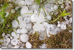
Hail is a form of precipitation which is recognized by large solid balls or
clumps of ice. Hail is created by thunderstorm clouds with strong updrafts of wind.
As the hailstones remain in the updraft, ice is deposited onto them until their
weight becomes heavy enough for them to fall to the earth's surface.
Hail storms can cause significant damage to crops, aircrafts, and man-made structures,
despite the fact that the duration is usually less than ten minutes.
Next Topic: Hole Punch Clouds
Weather Topic: What are Mammatus Clouds?
Home - Education - Cloud Types - Mammatus Clouds
 Next Topic: Nimbostratus Clouds
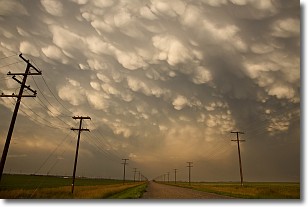
A mammatus cloud is a cloud with a unique feature which resembles
a web of pouches hanging along the base of the cloud.
In the United States, mammatus clouds tend to form in the warmer months, commonly
in the Midwest and eastern regions.
While they usually form at the bottom of a cumulonimbis cloud, they can also form
under altostratus, altocumulus, stratocumulus, and cirrus clouds. Mammatus clouds
warn that severe weather is close.
Next Topic: Nimbostratus Clouds
Current conditions powered by WeatherAPI.com


