Weather Alert in Illinois
Flood Watch issued April 2 at 11:06AM CDT until April 6 at 10:00PM CDT by NWS Chicago IL
AREAS AFFECTED: Bureau; Putnam; La Salle
DESCRIPTION: ...The Flood Watch is extended for the following rivers in Illinois... Illinois River at La Salle affecting Putnam, La Salle and Bureau zones. For the Illinois River (Upper)...including La Salle...flooding is possible. * WHAT...Flooding is possible. * WHERE...Illinois River from Starved Rock Lock and Dam downstream to confluence with Big Bureau Creek, including the La Salle gauge. * WHEN...From Friday afternoon to late Monday evening. * IMPACTS...At 22.0 feet, Lower parking lot at Starved Rock State Park is inundated east of La Salle. High water levels begin to impact shipping interests along the river. * ADDITIONAL DETAILS... - At 10:45 AM CDT Thursday the stage was 15.0 feet. - Forecast...Flood stage may be reached tomorrow afternoon. - Flood stage is 20.0 feet. - http://www.weather.gov/safety/flood
INSTRUCTION: A Flood Watch means water levels above flood stage are possible, but not yet certain, based upon the latest forecasts. Persons along rivers and streams in the watch area should monitor the latest forecasts and be prepared to take action should flooding develop. These forecasts are based on observed precipitation as well as forecast precipitation 24 hours into the future. Changes to the rainfall forecast, or any additional rainfall after 24 hours, may cause changes to these river forecasts. Additional information is available at www.weather.gov. The next statement will be issued by late tonight.
Want more detail? Get the Complete 7 Day and Night Detailed Forecast!
Current U.S. National Radar--Current
The Current National Weather Radar is shown below with a UTC Time (subtract 5 hours from UTC to get Eastern Time).

National Weather Forecast--Current
The Current National Weather Forecast and National Weather Map are shown below.

National Weather Forecast for Tomorrow
Tomorrow National Weather Forecast and Tomorrow National Weather Map are show below.

North America Water Vapor (Moisture)
This map shows recent moisture content over North America. Bright and colored areas show high moisture (ie, clouds); brown indicates very little moisture present; black indicates no moisture.

Weather Topic: What are Cumulonimbus Clouds?
Home - Education - Cloud Types - Cumulonimbus Clouds
 Next Topic: Cumulus Clouds
The final form taken by a growing cumulus cloud is the
cumulonimbus cloud, which is very tall and dense.
The tower of a cumulonimbus cloud can soar 23 km into the atmosphere, although
most commonly they stop growing at an altitude of 6 km.
Even small cumulonimbus clouds appear very large in comparison to other cloud types.
They can signal the approach of stormy weather, such as thunderstorms or blizzards.
Next Topic: Cumulus Clouds
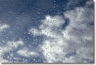
Weather Topic: What is Drizzle?
Home - Education - Precipitation - Drizzle
 Next Topic: Evaporation
Drizzle is precipitation in the form of water droplets which are
smaller than raindrops.
Drizzle is characterized by fine, gently falling droplets and typically does not
impact human habitation in a negative way. The exception to this is freezing drizzle,
a condition where drizzle freezes immediately upon reaching earth's surface.
Freezing drizzle is still less dangerous than freezing rain, but can
potentially result in hazardous road conditions.
Next Topic: Evaporation
Current conditions powered by WeatherAPI.com


