Weather Alert in New York
Heat Advisory issued June 21 at 2:59AM EDT until June 22 at 8:00PM EDT by NWS Albany NY
AREAS AFFECTED: Northern Saratoga; Eastern Schenectady; Southern Saratoga; Eastern Albany; Western Rensselaer; Eastern Greene; Western Columbia; Eastern Columbia; Southeast Warren; Southern Washington
DESCRIPTION: * WHAT...For the Heat Advisory, heat index values between 99 and 103 degrees expected. For the Extreme Heat Watch, dangerously hot conditions with heat index values up to 108 degrees possible. * WHERE...Eastern Albany, Eastern Columbia, Eastern Greene, Eastern Schenectady, Northern Saratoga, Southeast Warren, Southern Saratoga, Southern Washington, Western Columbia, and Western Rensselaer Counties. * WHEN...For the Heat Advisory, from 11 AM to 8 PM EDT Sunday. For the Extreme Heat Watch, from Monday morning through Tuesday evening. * IMPACTS...Heat related illnesses increase significantly during extreme heat and high humidity events. Hot temperatures and high humidity may cause heat illnesses.
INSTRUCTION: Drink plenty of fluids, stay in an air-conditioned room, stay out of the sun, and check up on relatives and neighbors.
Want more detail? Get the Complete 7 Day and Night Detailed Forecast!
Current U.S. National Radar--Current
The Current National Weather Radar is shown below with a UTC Time (subtract 5 hours from UTC to get Eastern Time).

National Weather Forecast--Current
The Current National Weather Forecast and National Weather Map are shown below.

National Weather Forecast for Tomorrow
Tomorrow National Weather Forecast and Tomorrow National Weather Map are show below.

North America Water Vapor (Moisture)
This map shows recent moisture content over North America. Bright and colored areas show high moisture (ie, clouds); brown indicates very little moisture present; black indicates no moisture.

Weather Topic: What is Condensation?
Home - Education - Precipitation - Condensation
 Next Topic: Contrails
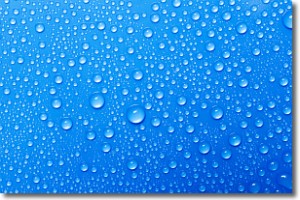
Condensation is the process which creates clouds, and therefore
it is a crucial process in the water cycle.
Condensation is the change of matter from a state of gas into a state of liquid,
and it happens because water molecules release heat into the atmosphere and
become organized into a more closely packed structure, what we might see as
water droplets.
Water is always present in the air around us as a vapor, but it's too small for
us to see. When water undergoes the process of condensation it becomes organized
into visible water droplets. You've probably seen condensation happen before on the
surface of a cold drink!
Next Topic: Contrails
Weather Topic: What are Cumulonimbus Clouds?
Home - Education - Cloud Types - Cumulonimbus Clouds
 Next Topic: Cumulus Clouds
The final form taken by a growing cumulus cloud is the
cumulonimbus cloud, which is very tall and dense.
The tower of a cumulonimbus cloud can soar 23 km into the atmosphere, although
most commonly they stop growing at an altitude of 6 km.
Even small cumulonimbus clouds appear very large in comparison to other cloud types.
They can signal the approach of stormy weather, such as thunderstorms or blizzards.
Next Topic: Cumulus Clouds
Current conditions powered by WeatherAPI.com


