Weather Alert in New Mexico
Red Flag Warning issued February 17 at 9:05PM MST until February 18 at 6:00PM MST by NWS El Paso Tx/Santa Teresa NM
AREAS AFFECTED: Southwest Deserts and Lowlands; South Central Lowlands And Southern Rio Grande Valley; Capitan And Sacramento Mountains; El Paso; Hudspeth
DESCRIPTION: ...CRITICAL FIRE WEATHER CONDITIONS FOR MUCH OF SOUTHERN NEW MEXICO AND FAR WEST TEXAS WEDNESDAY... .A passing upper level trough will lead to increasing dryness and strong winds on Wednesday. Sustained winds will approach 25 to 35 MPH for much of the area, with gusts around 45 MPH common. The strongest winds will favor along and east of the Sacramento Mountains, where gusts could reach upwards of 60 MPH. This will combine with minimum relative humidity in the low double digits and teens in the afternoon, creating high fire danger. * AFFECTED AREA...Fire Weather Zone 055 Texas Fire Weather Zone 055 El Paso County, Fire Weather Zone 056 Texas Fire Weather Zone 056 Hudspeth County, Fire Weather Zone 111 Southwest Deserts and Lowlands/Las Cruces BLM/GLZ, Fire Weather Zone 112 South Central Lowlands and Southern Rio Grande Valley/BLM/GLZ and Fire Weather Zone 113 Capitan and Sacramento Mountains/Lincoln NF/LNZ. * TIMING...11 AM to 6 PM Wednesday * WINDS...Southwest 25 to 35 mph with gusts up to 60 mph. * RELATIVE HUMIDITY...As low as 10 percent. * TEMPERATURES...Up to 68. * IMPACTS...Any fires that develop will likely spread rapidly. Outdoor burning is not recommended
INSTRUCTION: A Red Flag Warning means that critical fire weather conditions are either occurring now, or will shortly. A combination of strong winds, low relative humidity, and warm temperatures can contribute to extreme fire behavior.
Want more detail? Get the Complete 7 Day and Night Detailed Forecast!
Current U.S. National Radar--Current
The Current National Weather Radar is shown below with a UTC Time (subtract 5 hours from UTC to get Eastern Time).

National Weather Forecast--Current
The Current National Weather Forecast and National Weather Map are shown below.

National Weather Forecast for Tomorrow
Tomorrow National Weather Forecast and Tomorrow National Weather Map are show below.

North America Water Vapor (Moisture)
This map shows recent moisture content over North America. Bright and colored areas show high moisture (ie, clouds); brown indicates very little moisture present; black indicates no moisture.

Weather Topic: What is Drizzle?
Home - Education - Precipitation - Drizzle
 Next Topic: Evaporation
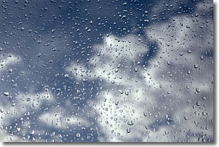
Drizzle is precipitation in the form of water droplets which are
smaller than raindrops.
Drizzle is characterized by fine, gently falling droplets and typically does not
impact human habitation in a negative way. The exception to this is freezing drizzle,
a condition where drizzle freezes immediately upon reaching earth's surface.
Freezing drizzle is still less dangerous than freezing rain, but can
potentially result in hazardous road conditions.
Next Topic: Evaporation
Weather Topic: What is Fog?
Home - Education - Cloud Types - Fog
 Next Topic: Fractus Clouds
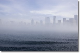
Fog is technically a type of stratus cloud, which lies along the
ground and obscures visibility.
It is usually created when humidity in the air condenses into tiny water droplets.
Because of this, some places are more prone to foggy weather, such as regions
close to a body of water.
Fog is similar to mist; both are the appearance of water droplets suspended in
the air, but fog is the term applied to the condition when visibility is less than 1 km.
Next Topic: Fractus Clouds
Current conditions powered by WeatherAPI.com


