Weather Alert in Colorado
Flood Watch issued August 25 at 12:17PM MDT until August 26 at 12:00AM MDT by NWS Pueblo CO
AREAS AFFECTED: Northern Sangre de Cristo Mountains Between 8500 And 11000 Ft; Northern Sangre de Cristo Mountains above 11000 Ft; Southern Sangre De Cristo Mountains Between 7500 and 11000 Ft; Southern Sangre De Cristo Mountains Above 11000 Ft; Northwestern Fremont County Above 8500Ft; Western/Central Fremont County Below 8500 Ft; Wet Mountain Valley Below 8500 Ft; Wet Mountains between 6300 and 10000Ft; Wet Mountains above 10000 Ft; Teller County/Rampart Range above 7500fT/Pike's Peak Between 7500 And 11000 Ft; Pikes Peak above 11000 Ft; Canon City Vicinity/Eastern Fremont County; Northern El Paso County/Monument Ridge/Rampart Range Below 7500 Ft; Colorado Springs Vicinity/Southern El Paso County/Rampart Range Below 7400 Ft; Pueblo Vicinity/Pueblo County Below 6300 Feet; Walsenburg Vicinity/Upper Huerfano River Basin Below 7500 Ft; Trinidad Vicinity/Western Las Animas County Below 7500 Ft
DESCRIPTION: * WHAT...Flash flooding caused by excessive rainfall continues to be possible. * WHERE...Portions of central, east central, and southeast Colorado, including the following areas, in central Colorado, Canon City Vicinity/Eastern Fremont County, Northwestern Fremont County Above 8500 Feet, Pikes Peak Above 11000 Feet, Teller County/Rampart Range Above 7500 Feet/Pikes Peak Between 7500 And 11000 Feet and Western/Central Fremont County Below 8500 Feet. In east central Colorado, Colorado Springs Vicinity/Southern El Paso County/Rampart Range Below 7400 Feet and Northern El Paso County/Monument Ridge/Rampart Range Below 7500 Feet. In southeast Colorado, Northern Sangre de Cristo Mountains Above 11000 Feet, Northern Sangre de Cristo Mountains Between 8500 And 11000 Feet, Pueblo Vicinity/Pueblo County Below 6300 Feet, Southern Sangre de Cristo Mountains Above 11000 Feet, Southern Sangre de Cristo Mountains Between 7500 and 11000 Feet, Trinidad Vicinity/Western Las Animas County Below 7500 Feet, Walsenburg Vicinity/Upper Huerfano River Basin Below 7500 Feet, Wet Mountain Valley Below 8500 Feet, Wet Mountains Above 10000 Feet and Wet Mountains between 6300 and 10000 Feet. * WHEN...Until midnight MDT tonight. * IMPACTS...Excessive runoff may result in flooding of rivers, creeks, streams, and other low-lying and flood-prone locations. * ADDITIONAL DETAILS... - http://www.weather.gov/safety/flood
INSTRUCTION: You should monitor later forecasts and be prepared to take action should Flash Flood Warnings be issued.
Want more detail? Get the Complete 7 Day and Night Detailed Forecast!
Current U.S. National Radar--Current
The Current National Weather Radar is shown below with a UTC Time (subtract 5 hours from UTC to get Eastern Time).

National Weather Forecast--Current
The Current National Weather Forecast and National Weather Map are shown below.

National Weather Forecast for Tomorrow
Tomorrow National Weather Forecast and Tomorrow National Weather Map are show below.

North America Water Vapor (Moisture)
This map shows recent moisture content over North America. Bright and colored areas show high moisture (ie, clouds); brown indicates very little moisture present; black indicates no moisture.

Weather Topic: What are Fractus Clouds?
Home - Education - Cloud Types - Fractus Clouds
 Next Topic: Freezing Rain
A fractus cloud (scud) is a fragmented, tattered cloud which has
likely been sheared off of another cloud. They are accessory clouds, meaning they
develop from parent clouds, and are named in a way which describes the original
cloud which contained them.
Fractus clouds which have originated from cumulus clouds are referred to as
cumulus fractus, while fractus clouds which have originated from stratus clouds
are referred to as stratus fractus. Under certain conditions a fractus cloud might
merge with another cloud, or develop into a cumulus cloud, but usually a
fractus cloud seen by itself will dissipate rapidly.
They are often observed on the leading and trailing edges of storm clouds,
and are a display of wind activity.
Next Topic: Freezing Rain
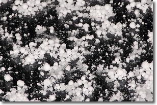
Weather Topic: What is Graupel?
Home - Education - Precipitation - Graupel
 Next Topic: Hail
Graupel is a form of precipitation that is created by atmospheric conditions
which cause supercooled water droplets to contact snow crystals and freeze to
their surface.
Sometimes known as soft hail or snow pellets, graupel is delicate and easily
destroyed by touch. Whereas hail usually falls during severe weather, graupel
doesn't require such conditions to form, and can form in mild precipitation
similar to situations which produce snowfall.
Next Topic: Hail
Current conditions powered by WeatherAPI.com


