Weather Alert in Colorado
Avalanche Watch issued February 10 at 4:38PM MST by NWS Denver CO
AREAS AFFECTED: Elkhead and Park Mountains; West Elk and Sawatch Mountains; Flat Tops; West Jackson and West Grand Counties Above 9000 Feet
DESCRIPTION: AVABOU THE FOLLOWING MESSAGE IS TRANSMITTED AT THE REQUEST OF THE COLORADO AVALANCHE INFORMATION CENTER. AVALANCHE WATCH IN EFFECT FROM 5:00 PM TUESDAY UNTIL 5:00 PM WEDNESDAY *WHAT Dangerous avalanche conditions are taking shape. Expect the Avalanche Danger to rise to HIGH (Level 4 of 5) by late Wednesday evening. *WHERE Park Range, Flat Tops, Elk heads, and Ruby Raggeds *WHEN Expect dangerous avalanche conditions to begin overnight Wednesday and last through Thursday. *IMPACTS Heavy snow and wind, drifting snow, will create dangerous avalanche conditions. Large and dangerous avalanches will be easy to trigger once the new snow accumulates. Avalanches will run naturally. *PRECAUTION/PREPAREDNESS ACTIONS Travel in backcountry avalanche terrain is not recommended on THURSDAY. Avoid travel on and under slopes with a slope angle steeper than about 30 degrees. You can find more detailed information at colorado.gov/avalanche Davis
INSTRUCTION: N/A
Want more detail? Get the Complete 7 Day and Night Detailed Forecast!
Current U.S. National Radar--Current
The Current National Weather Radar is shown below with a UTC Time (subtract 5 hours from UTC to get Eastern Time).

National Weather Forecast--Current
The Current National Weather Forecast and National Weather Map are shown below.

National Weather Forecast for Tomorrow
Tomorrow National Weather Forecast and Tomorrow National Weather Map are show below.

North America Water Vapor (Moisture)
This map shows recent moisture content over North America. Bright and colored areas show high moisture (ie, clouds); brown indicates very little moisture present; black indicates no moisture.

Weather Topic: What is Hail?
Home - Education - Precipitation - Hail
 Next Topic: Hole Punch Clouds
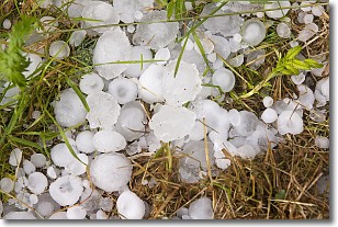
Hail is a form of precipitation which is recognized by large solid balls or
clumps of ice. Hail is created by thunderstorm clouds with strong updrafts of wind.
As the hailstones remain in the updraft, ice is deposited onto them until their
weight becomes heavy enough for them to fall to the earth's surface.
Hail storms can cause significant damage to crops, aircrafts, and man-made structures,
despite the fact that the duration is usually less than ten minutes.
Next Topic: Hole Punch Clouds
Weather Topic: What are Mammatus Clouds?
Home - Education - Cloud Types - Mammatus Clouds
 Next Topic: Nimbostratus Clouds
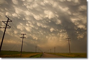
A mammatus cloud is a cloud with a unique feature which resembles
a web of pouches hanging along the base of the cloud.
In the United States, mammatus clouds tend to form in the warmer months, commonly
in the Midwest and eastern regions.
While they usually form at the bottom of a cumulonimbis cloud, they can also form
under altostratus, altocumulus, stratocumulus, and cirrus clouds. Mammatus clouds
warn that severe weather is close.
Next Topic: Nimbostratus Clouds
Current conditions powered by WeatherAPI.com


