Weather Alert in Arizona
Flash Flood Warning issued September 4 at 12:40PM MST until September 4 at 3:45PM MST by NWS Flagstaff AZ
AREAS AFFECTED: Coconino, AZ
DESCRIPTION: FFWFGZ The National Weather Service in Flagstaff has issued a * Flash Flood Warning for...The South Canyon Wash Basin downstream of the Dragon Bravo Fire...in Coconino County in north central Arizona...this includes the Colorado River between river miles 32 and 48. * Until 345 PM MST /445 PM MDT/. * At 1240 PM MST /140 PM MDT/, Doppler radar indicated thunderstorms producing heavy rain over the South Canyon Wash Basin downstream of the Dragon Bravo Fire. Flash flooding is ongoing or expected to begin shortly. Excessive rainfall over the burn scar will result in debris flow moving through the South Canyon Wash and other washes downriver to river mile 48. The debris flow can consist of rock, mud, vegetation and other loose materials. HAZARD...Life threatening flash flooding. Thunderstorms producing flash flooding in and around the South Canyon Wash Basin downstream of the Dragon Bravo Fire. SOURCE...Radar indicated. IMPACT...Life threatening flash flooding of areas in and around the South Canyon Wash Basin downstream of the Dragon Bravo Fire. * Some locations that will experience flash flooding include... Grand Canyon National Park, Bert Loper's Boat, Royal Arches, Triple Alcoves, Point Hansbrough, Anasazi Foot Bridge and Saddle Mountain Wilderness. This includes the Colorado River between river miles 32 and 48. This includes the following recreation areas and campgrounds... South Canyon Camp Site, Below Redwall Camp Site, Little Redwall Camp Site, Nautiloid Camp Site, Tatahatso Wash Camp Site, Tatahatso Camp Site, Above Martha's Camp Site, Martha's Camp Site, Redbud Alcove Camp Site, MCD Site Camp Site, Upper Buck Farm Camp Site, Buck Farm Camp Site, Below Buck Farm Camp Site, Loper's Boat Camp Site, Royal Arches Camp Site, Anasazi Bridge Camp Site, Lower Anasazi Camp Site, President Harding Camp Site, Eminence Camp Site, Above Willie Taylor Camp Site, Willie Taylor Camp Site, Triple Alcoves Camp Site, Duck N Quack Camp Site, Upper Saddle Camp Site and Lower Saddle Camp Site. This includes the following creeks, washes and rivers... Saddle Canyon, Colorado River, Buck Farm Canyon, South Canyon, "Bert's Canyon", Nautiloid Canyon, Tatahoysa Wash, "Redbud Alcove" and Tatahatso Wash.
INSTRUCTION: This is a life threatening situation. Heavy rainfall will cause extensive and severe flash flooding of creeks...streams...and ditches in the South Canyon Wash Basin downstream of the Dragon Bravo Fire. Severe debris flows can also be anticipated across roads. Roads and driveways may be washed away in places. If you encounter flood waters...climb to safety.
Want more detail? Get the Complete 7 Day and Night Detailed Forecast!
Current U.S. National Radar--Current
The Current National Weather Radar is shown below with a UTC Time (subtract 5 hours from UTC to get Eastern Time).

National Weather Forecast--Current
The Current National Weather Forecast and National Weather Map are shown below.

National Weather Forecast for Tomorrow
Tomorrow National Weather Forecast and Tomorrow National Weather Map are show below.

North America Water Vapor (Moisture)
This map shows recent moisture content over North America. Bright and colored areas show high moisture (ie, clouds); brown indicates very little moisture present; black indicates no moisture.

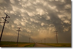
Weather Topic: What are Mammatus Clouds?
Home - Education - Cloud Types - Mammatus Clouds
 Next Topic: Nimbostratus Clouds
A mammatus cloud is a cloud with a unique feature which resembles
a web of pouches hanging along the base of the cloud.
In the United States, mammatus clouds tend to form in the warmer months, commonly
in the Midwest and eastern regions.
While they usually form at the bottom of a cumulonimbis cloud, they can also form
under altostratus, altocumulus, stratocumulus, and cirrus clouds. Mammatus clouds
warn that severe weather is close.
Next Topic: Nimbostratus Clouds
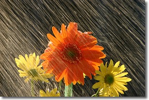
Weather Topic: What is Precipitation?
Home - Education - Precipitation - Precipitation
 Next Topic: Rain
Precipitation can refer to many different forms of water that
may fall from clouds. Precipitation occurs after a cloud has become saturated to
the point where its water particles are more dense than the air below the cloud.
In most cases, precipitation will reach the ground, but it is not uncommon for
precipitation to evaporate before it reaches the earth's surface.
When precipitation evaporates before it contacts the ground it is called Virga.
Graupel, hail, sleet, rain, drizzle, and snow are forms of precipitation, but fog
and mist are not considered precipitation because the water vapor which
constitutes them isn't dense enough to fall to the ground.
Next Topic: Rain
Current conditions powered by WeatherAPI.com


