Weather Alert in Montana
Avalanche Watch issued February 16 at 1:45PM MST by NWS Missoula MT
AREAS AFFECTED: West Glacier Region
DESCRIPTION: AVAMSO The following message is transmitted at the request of Flathead Avalanche Center Hungry Horse MT. ...AVALANCHE WATCH ISSUED BY THE FLATHEAD AVALANCHE CENTER... 14:00 MST Mon Feb 16 2026 The Flathead Avalanche Center in Hungry Horse has issued a BACKCOUNTRY AVALANCHE WATCH for the following areas: NWS Missoula MT - MTZ002 (MTZ002) * WHAT...The avalanche danger is anticipated to increase to High (Level 4 of 5) Tuesday as an incoming storm brings heavy snow and strong winds to the forecast region. * WHERE...Mid and upper elevations in the Swan, Flathead, and Whitefish Ranges, and portions of Glacier National Park (the Apgar Range, the Lake McDonald Valley, and Marias Pass). * WHEN...In effect from Mon 14:00 MST to Tue 14:00 MST. * IMPACTS...A foot or more of new snow is forecasted at mid and upper- elevations. Moderate winds may drift snow into steep start zones. Many slopes and start zones harbor weak layers that are already sensitive to human triggers. The additional loading makes large to very large natural and triggered avalanches likely. Remotely-triggered avalanches will also be possible.</p> * PRECAUTIONARY / PREPAREDNESS ACTIONS...If the snowfall arrives as forecast, very dangerous avalanche conditions may develop. Travel in avalanche terrain is not recommended in these conditions. Avalanches may be triggered from below or from adjacent slopes. Avalanches may run long distances and can run into mature forests, valley floors, or flat terrain. Consult http://www.flatheadavalanche.org/ or www.avalanche.org for more detailed information. Similar avalanche danger may exist at locations outside the coverage area of this or any avalanche center.
INSTRUCTION: N/A
Want more detail? Get the Complete 7 Day and Night Detailed Forecast!
Current U.S. National Radar--Current
The Current National Weather Radar is shown below with a UTC Time (subtract 5 hours from UTC to get Eastern Time).

National Weather Forecast--Current
The Current National Weather Forecast and National Weather Map are shown below.

National Weather Forecast for Tomorrow
Tomorrow National Weather Forecast and Tomorrow National Weather Map are show below.

North America Water Vapor (Moisture)
This map shows recent moisture content over North America. Bright and colored areas show high moisture (ie, clouds); brown indicates very little moisture present; black indicates no moisture.

Weather Topic: What are Fractus Clouds?
Home - Education - Cloud Types - Fractus Clouds
 Next Topic: Freezing Rain
A fractus cloud (scud) is a fragmented, tattered cloud which has
likely been sheared off of another cloud. They are accessory clouds, meaning they
develop from parent clouds, and are named in a way which describes the original
cloud which contained them.
Fractus clouds which have originated from cumulus clouds are referred to as
cumulus fractus, while fractus clouds which have originated from stratus clouds
are referred to as stratus fractus. Under certain conditions a fractus cloud might
merge with another cloud, or develop into a cumulus cloud, but usually a
fractus cloud seen by itself will dissipate rapidly.
They are often observed on the leading and trailing edges of storm clouds,
and are a display of wind activity.
Next Topic: Freezing Rain
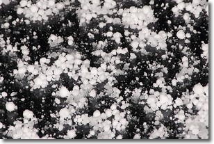
Weather Topic: What is Graupel?
Home - Education - Precipitation - Graupel
 Next Topic: Hail
Graupel is a form of precipitation that is created by atmospheric conditions
which cause supercooled water droplets to contact snow crystals and freeze to
their surface.
Sometimes known as soft hail or snow pellets, graupel is delicate and easily
destroyed by touch. Whereas hail usually falls during severe weather, graupel
doesn't require such conditions to form, and can form in mild precipitation
similar to situations which produce snowfall.
Next Topic: Hail
Current conditions powered by WeatherAPI.com


