Weather Alert in Alaska
High Wind Watch issued February 24 at 5:31AM AKST until February 25 at 9:00PM AKST by NWS Anchorage AK
AREAS AFFECTED: Kodiak Island Northeast
DESCRIPTION: * WHAT...Northwest winds 35 to 50 mph with gusts up to 75 mph possible. Wind chills dropping as low as 15 below zero Wednesday morning. * WHERE...Northeast end of Kodiak Island, including Kodiak City. * WHEN...From late tonight through Wednesday evening. * IMPACTS...High winds could move loose debris, damage property, and cause power outages. Travel could be difficult. Wind chills as low as 15 below zero could result in hypothermia or frostbite if precautions are not taken. * ADDITIONAL DETAILS...The pattern is very similar to last Thursday night when Kodiak City observed high winds, with cold Arctic air surging across Kodiak Island Tuesday night through Wednesday. There is a subtle difference in the upper levels, with a disturbance possible passing just north of the island instead of passing overhead. Thus, winds in this upcoming event could be just a bit weaker than last Thursday night. The strongest winds are expected Wednesday morning.
INSTRUCTION: A high wind watch means there is potential for a hazardous high wind event. Monitor the latest forecasts and warnings for updates on this situation. Fasten loose objects or shelter objects in a safe location prior to the onset of winds.
Want more detail? Get the Complete 7 Day and Night Detailed Forecast!
Current U.S. National Radar--Current
The Current National Weather Radar is shown below with a UTC Time (subtract 5 hours from UTC to get Eastern Time).

National Weather Forecast--Current
The Current National Weather Forecast and National Weather Map are shown below.

National Weather Forecast for Tomorrow
Tomorrow National Weather Forecast and Tomorrow National Weather Map are show below.

North America Water Vapor (Moisture)
This map shows recent moisture content over North America. Bright and colored areas show high moisture (ie, clouds); brown indicates very little moisture present; black indicates no moisture.

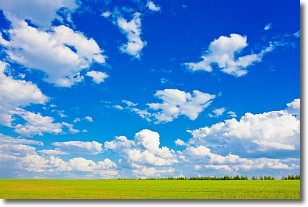
Weather Topic: What are Cumulus Clouds?
Home - Education - Cloud Types - Cumulus Clouds
 Next Topic: Drizzle
Cumulus clouds are fluffy and textured with rounded tops, and
may have flat bottoms. The border of a cumulus cloud
is clearly defined, and can have the appearance of cotton or cauliflower.
Cumulus clouds form at low altitudes (rarely above 2 km) but can grow very tall,
becoming cumulus congestus and possibly the even taller cumulonimbus clouds.
When cumulus clouds become taller, they have a greater chance of producing precipitation.
Next Topic: Drizzle
Weather Topic: What is Evaporation?
Home - Education - Precipitation - Evaporation
 Next Topic: Fog
Evaporation is the process which returns water from the earth
back to the atmosphere, and is another crucial process in the water cycle.
Evaporation is the transformation of liquid into gas, and it happens because
molecules are excited by the application of energy and turn into vapor.
In order for water to evaporate it has to be on the surface of a body of water.
Next Topic: Fog
Current conditions powered by WeatherAPI.com


