Weather Alert in Arizona
Dust Storm Warning issued June 30 at 7:00PM MST until June 30 at 8:15PM MST by NWS Tucson AZ
AREAS AFFECTED: Pima, AZ; Santa Cruz, AZ
DESCRIPTION: The National Weather Service in Tucson has issued a * Dust Storm Warning for... Eastern Pima County in southeastern Arizona... Santa Cruz County in southeastern Arizona... * Until 815 PM MST. * At 700 PM MST, an area of blowing dust was moving across eastern Pima county including the city of Tucson, moving southwest at 20 mph. HAZARD...Less than a quarter mile visibility with damaging winds in excess of 60 mph. SOURCE...Detected by National Weather Service meteorologists. IMPACT...Dangerous life-threatening travel. * Locations impacted include... Tucson, Oro Valley, Marana, Sahuarita, Green Valley, Nogales, Tubac, Davis-Monthan Air Force Base, Casas Adobes, Drexel Heights, Rio Rico, Flowing Wells, Tanque Verde, Vail, Corona De Tucson, South Tucson, Three Points, Pascua Pueblo Yaqui Reservation, Tortolita and East Sahuarita. This includes the following highways... Interstate 19 between mile markers 1 and 63. Route 86 between mile markers 151 and 171. Route 77 between mile markers 70 and 80. Interstate 10 between mile markers 241 and 294. Route 82 between mile markers 1 and 43. Route 286 between mile markers 44 and 45. Route 83 between mile markers 10 and 58.
INSTRUCTION: Motorists should not drive into a dust storm. PULL ASIDE STAY ALIVE! Dust storms lead to dangerous driving conditions with visibility reduced to near zero. If driving, avoid dust storms if possible. If caught in one, pull off the road, turn off your lights and keep your foot off the brake.
Want more detail? Get the Complete 7 Day and Night Detailed Forecast!
Current U.S. National Radar--Current
The Current National Weather Radar is shown below with a UTC Time (subtract 5 hours from UTC to get Eastern Time).

National Weather Forecast--Current
The Current National Weather Forecast and National Weather Map are shown below.

National Weather Forecast for Tomorrow
Tomorrow National Weather Forecast and Tomorrow National Weather Map are show below.

North America Water Vapor (Moisture)
This map shows recent moisture content over North America. Bright and colored areas show high moisture (ie, clouds); brown indicates very little moisture present; black indicates no moisture.

Weather Topic: What are Cumulonimbus Clouds?
Home - Education - Cloud Types - Cumulonimbus Clouds
 Next Topic: Cumulus Clouds
The final form taken by a growing cumulus cloud is the
cumulonimbus cloud, which is very tall and dense.
The tower of a cumulonimbus cloud can soar 23 km into the atmosphere, although
most commonly they stop growing at an altitude of 6 km.
Even small cumulonimbus clouds appear very large in comparison to other cloud types.
They can signal the approach of stormy weather, such as thunderstorms or blizzards.
Next Topic: Cumulus Clouds
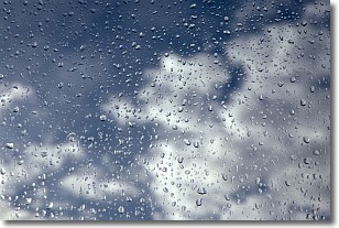
Weather Topic: What is Drizzle?
Home - Education - Precipitation - Drizzle
 Next Topic: Evaporation
Drizzle is precipitation in the form of water droplets which are
smaller than raindrops.
Drizzle is characterized by fine, gently falling droplets and typically does not
impact human habitation in a negative way. The exception to this is freezing drizzle,
a condition where drizzle freezes immediately upon reaching earth's surface.
Freezing drizzle is still less dangerous than freezing rain, but can
potentially result in hazardous road conditions.
Next Topic: Evaporation
Current conditions powered by WeatherAPI.com


