Weather Alert in California
Winter Weather Advisory issued March 31 at 7:41PM PDT until April 2 at 8:00AM PDT by NWS Sacramento CA
AREAS AFFECTED: West Slope Northern Sierra Nevada
DESCRIPTION: * WHAT...Light to moderate snow. Total snow accumulations 6 to 12 inches above 6000 feet, including Donner Pass. Locally higher accumulations over peaks. Winds gusting as high as 55 mph. * WHERE...West Slope Northern Sierra Nevada above 6000 feet. * WHEN...Until 8 AM PDT Thursday. * IMPACTS...Travel could be very difficult. The hazardous conditions could impact the Tuesday evening through Wednesday commutes. Strong winds could cause tree damage. * ADDITIONAL DETAILS...Snow levels 6500-7000 feet, lowering to 5500-6500 feet Wednesday evening.
INSTRUCTION: Check the latest road conditions from Caltrans online at quickmap.dot.ca.gov or dial 5 1 1.
Want more detail? Get the Complete 7 Day and Night Detailed Forecast!
Current U.S. National Radar--Current
The Current National Weather Radar is shown below with a UTC Time (subtract 5 hours from UTC to get Eastern Time).

National Weather Forecast--Current
The Current National Weather Forecast and National Weather Map are shown below.

National Weather Forecast for Tomorrow
Tomorrow National Weather Forecast and Tomorrow National Weather Map are show below.

North America Water Vapor (Moisture)
This map shows recent moisture content over North America. Bright and colored areas show high moisture (ie, clouds); brown indicates very little moisture present; black indicates no moisture.

Weather Topic: What are Altostratus Clouds?
Home - Education - Cloud Types - Altostratus Clouds
 Next Topic: Cirrocumulus Clouds
Altostratus clouds form at mid to high-level altitudes
(between 2 and 7 km) and are created by a warm, stable air mass which causes
water vapor
to condense as it rise through the atmosphere. Usually altostratus clouds are
featureless sheets characterized by a uniform color.
In some cases, wind punching through the cloud formation may give it a waved
appearance, called altostratus undulatus. Altostratus clouds
are commonly seen with other cloud formations accompanying them.
Next Topic: Cirrocumulus Clouds
Weather Topic: What are Cirrostratus Clouds?
Home - Education - Cloud Types - Cirrostratus Clouds
 Next Topic: Cirrus Clouds
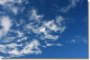
Cirrostratus clouds are high, thin clouds that form above
20,000 feet and are made mostly of ice crystals. They sometimes look like giant
feathers, horse tails, or curls of hair in the sky.
These clouds are pushed by the jet stream and can move at high speeds reaching
100 mph.
What do they indicate?
They indicate that a precipitation is likely within 24 hours.
Next Topic: Cirrus Clouds
Current conditions powered by WeatherAPI.com


