Weather Alert in Colorado
Fire Weather Watch issued February 17 at 10:43AM MST until February 18 at 5:00PM MST by NWS Goodland KS
AREAS AFFECTED: Yuma; Kit Carson County; Cheyenne; Cheyenne; Sherman; Wallace; Greeley
DESCRIPTION: Red Flag Warnings continue today for the entire area. This is particularly dangerous situation for western areas due to the combination of strong winds, low humidity and dry fuels. A new Fire Weather Watch has been issued for tomorrow for areas generally along and west of a line from Wray, Colorado, to Russell Springs and Leoti, Kansas. Southwest winds will increase in the afternoon with gusts of 25 to 45 mph and humidity as low as 15 percent. The National Weather Service in Goodland has issued a Fire Weather Watch for wind and low relative humidity, which is in effect from Wednesday morning through Wednesday afternoon. * AFFECTED AREA...THIS IS A PARTICULARLY DANGEROUS SITUATION FOR Fire Weather Zones 001 Cheyenne, 013 Sherman, 027 Wallace, 041 Greeley, 252 Yuma, 253 Kit Carson and 254 Cheyenne. * TIMING...For the Red Flag Warning, until 8 PM MST /9 PM CST/ this evening. For the Fire Weather Watch, from Wednesday morning through Wednesday afternoon. * WINDS...Southwest 35 to 45 mph with gusts up to 65 mph. * RELATIVE HUMIDITY...As low as 12 percent. * IMPACTS...Extremely dangerous and erratic fire behavior. Any fires that develop will rapidly grow and spread out of control.
INSTRUCTION: Comply with burn bans and regulations. Avoid driving on dry grass or brush. Maintain vehicle brakes and tires and secure tow chains to avoid dragging. Mow lawns early in the morning, when it isn't windy or excessively dry. Never toss lit cigarettes onto the ground. Evacuate if fire/smoke is heading your way, or if ordered to do so by local officials.
Want more detail? Get the Complete 7 Day and Night Detailed Forecast!
Current U.S. National Radar--Current
The Current National Weather Radar is shown below with a UTC Time (subtract 5 hours from UTC to get Eastern Time).

National Weather Forecast--Current
The Current National Weather Forecast and National Weather Map are shown below.

National Weather Forecast for Tomorrow
Tomorrow National Weather Forecast and Tomorrow National Weather Map are show below.

North America Water Vapor (Moisture)
This map shows recent moisture content over North America. Bright and colored areas show high moisture (ie, clouds); brown indicates very little moisture present; black indicates no moisture.

Weather Topic: What is Freezing Rain?
Home - Education - Precipitation - Freezing Rain
 Next Topic: Graupel
Freezing rain is a condition where precipitation which has fallen in the form of
water droplets reaches temperatures which are below freezing and freezes upon
coming into contact
with surface objects. The result of this precipitation is a glaze of ice which
can be damaging to plants and man-made structures. A severe onset of freezing
rain which results in a very thick glaze of ice is known as an ice storm.
Next Topic: Graupel
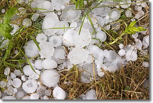
Weather Topic: What is Hail?
Home - Education - Precipitation - Hail
 Next Topic: Hole Punch Clouds
Hail is a form of precipitation which is recognized by large solid balls or
clumps of ice. Hail is created by thunderstorm clouds with strong updrafts of wind.
As the hailstones remain in the updraft, ice is deposited onto them until their
weight becomes heavy enough for them to fall to the earth's surface.
Hail storms can cause significant damage to crops, aircrafts, and man-made structures,
despite the fact that the duration is usually less than ten minutes.
Next Topic: Hole Punch Clouds
Current conditions powered by WeatherAPI.com


