Weather Alert in Alaska
Flood Watch issued September 2 at 7:41AM AKDT until September 7 at 10:00AM AKDT by NWS Anchorage AK
AREAS AFFECTED: NW Kenai Peninsula; Skilak Lake
DESCRIPTION: * WHAT...Flooding caused by the Skilak glacier-dammed lake release is possible. * WHERE...Skilak Lake and the Middle Kenai River near Skilak Lake and the Kenai River Downstream of Skilak Lake. * WHEN...Through Sunday morning. * IMPACTS...Kenai River level forecasts: Currently expecting the Kenai River to rise steadily at Skilak Lake outlet another 2 feet, cresting at moderate flood stage Friday or Saturday. At the Kenai Keys, expecting the Kenai River to rise another 2 to 2.5 feet, cresting just below moderate flood stage of 12 feet Friday or Saturday. Down river at Soldotna, expecting the Kenai River to rise steadily through week, cresting Saturday above bankfull levels near 12 feet. IMPACTS: Expect steady river level increases next 4 days on lower Kenai River. Flooding of low lying areas in the Kenai Keys area, boat dock issues and extended period of high water and bankfull conditions is likely. Excessive runoff may result in flooding of rivers, creeks, streams, and other low-lying and flood-prone locations. * ADDITIONAL DETAILS... - Skilak Glacier Dam Lake is likely releasing. This combined with recent significant rain in the upper Kenai River basin will cause Kenai river levels to rise steadily from the outlet of Skilak Lake to the mouth through the end of this week. Some uncertainty exists due to recent rain as to when the Skilak Glacier Dam lake began releasing which could impact the crest timing and height. Planned aerial reconnaissance of Skilak Glacier Dam Lake will confirm whether a release has taken place and the extent of any release. - Http://www.weather.gov/safety/flood
INSTRUCTION: You should monitor later forecasts and be alert for possible Flood Warnings. Those living in areas prone to flooding should be prepared to take action should flooding develop. Stay tuned to further developments by listening to your local radio, television, or NOAA Weather Radio for further information.
Want more detail? Get the Complete 7 Day and Night Detailed Forecast!
Current U.S. National Radar--Current
The Current National Weather Radar is shown below with a UTC Time (subtract 5 hours from UTC to get Eastern Time).

National Weather Forecast--Current
The Current National Weather Forecast and National Weather Map are shown below.

National Weather Forecast for Tomorrow
Tomorrow National Weather Forecast and Tomorrow National Weather Map are show below.

North America Water Vapor (Moisture)
This map shows recent moisture content over North America. Bright and colored areas show high moisture (ie, clouds); brown indicates very little moisture present; black indicates no moisture.

Weather Topic: What is Hail?
Home - Education - Precipitation - Hail
 Next Topic: Hole Punch Clouds
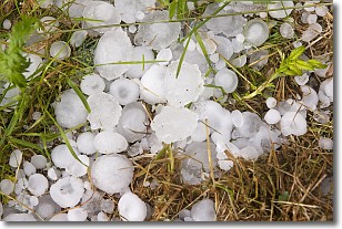
Hail is a form of precipitation which is recognized by large solid balls or
clumps of ice. Hail is created by thunderstorm clouds with strong updrafts of wind.
As the hailstones remain in the updraft, ice is deposited onto them until their
weight becomes heavy enough for them to fall to the earth's surface.
Hail storms can cause significant damage to crops, aircrafts, and man-made structures,
despite the fact that the duration is usually less than ten minutes.
Next Topic: Hole Punch Clouds
Weather Topic: What are Mammatus Clouds?
Home - Education - Cloud Types - Mammatus Clouds
 Next Topic: Nimbostratus Clouds
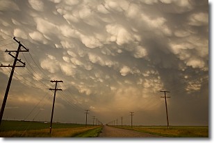
A mammatus cloud is a cloud with a unique feature which resembles
a web of pouches hanging along the base of the cloud.
In the United States, mammatus clouds tend to form in the warmer months, commonly
in the Midwest and eastern regions.
While they usually form at the bottom of a cumulonimbis cloud, they can also form
under altostratus, altocumulus, stratocumulus, and cirrus clouds. Mammatus clouds
warn that severe weather is close.
Next Topic: Nimbostratus Clouds
Current conditions powered by WeatherAPI.com


