Weather Alert in California
Red Flag Warning issued June 30 at 11:30AM PDT until June 30 at 11:00PM PDT by NWS Eureka CA
AREAS AFFECTED: Lower Middle Klamath; Hoopa; Van Duzen/Mad River; W Mendocino NF/E Mendocino Unit; Trinity
DESCRIPTION: ...SCATTERED DRY LIGHTNING IS LIKELY MONDAY AND TUESDAY AFTERNOON ACROSS THE INTERIOR MOUNTAINS... .A pulse of moisture moving up the Central Valley combined with very hot and dry surface conditions and moderate easterly winds will combine to create scattered dry thunderstorms over the interior mountains. Any storms that do form will likely produce wetting rain in the cores but lightning is possible far from these cores in areas that will remain dry. Storms Monday are most likely over Northern Trinity and Interior Humboldt with moderate movement towards the coast. Storms Tuesday will be more stationary and are most likely to form over Trinity, Northern Mendocino and possibly Del Norte. The National Weather Service in Eureka has issued a Red Flag Warning, which is in effect from 11 AM to 11 PM PDT Tuesday. The Fire Weather Watch is no longer in effect. * OUTFLOW WINDS...Gusty and erratic outflow winds are possible up to 50 mph. * IMPACTS...any fires that develop will likely spread rapidly. Outdoor burning is not recommended.
INSTRUCTION: A Red Flag Warning means that critical fire weather conditions are either occurring now, or will shortly. A combination of strong winds, low relative humidity, and warm temperatures can contribute to extreme fire behavior.
Want more detail? Get the Complete 7 Day and Night Detailed Forecast!
Current U.S. National Radar--Current
The Current National Weather Radar is shown below with a UTC Time (subtract 5 hours from UTC to get Eastern Time).

National Weather Forecast--Current
The Current National Weather Forecast and National Weather Map are shown below.

National Weather Forecast for Tomorrow
Tomorrow National Weather Forecast and Tomorrow National Weather Map are show below.

North America Water Vapor (Moisture)
This map shows recent moisture content over North America. Bright and colored areas show high moisture (ie, clouds); brown indicates very little moisture present; black indicates no moisture.

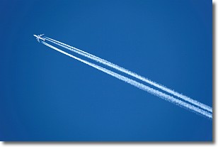
Weather Topic: What are Contrails?
Home - Education - Cloud Types - Contrails
 Next Topic: Cumulonimbus Clouds
A contrail is an artificial cloud, created by the passing of an
aircraft.
Contrails form because water vapor in the exhaust of aircraft engines is suspended
in the air under certain temperatures and humidity conditions. These contrails
are called exhaust contrails.
Another type of contrail can form due to a temporary reduction in air pressure
moving over the plane's surface, causing condensation.
These are called aerodynamic contrails.
When you can see your breath on a cold day, it is also because of condensation.
The reason contrails last longer than the condensation from your breath is
because the water in contrails freezes into ice particles.
Next Topic: Cumulonimbus Clouds
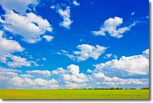
Weather Topic: What are Cumulus Clouds?
Home - Education - Cloud Types - Cumulus Clouds
 Next Topic: Drizzle
Cumulus clouds are fluffy and textured with rounded tops, and
may have flat bottoms. The border of a cumulus cloud
is clearly defined, and can have the appearance of cotton or cauliflower.
Cumulus clouds form at low altitudes (rarely above 2 km) but can grow very tall,
becoming cumulus congestus and possibly the even taller cumulonimbus clouds.
When cumulus clouds become taller, they have a greater chance of producing precipitation.
Next Topic: Drizzle
Current conditions powered by WeatherAPI.com


