Weather Alert in Wyoming
High Wind Warning issued February 23 at 2:56AM MST until February 24 at 5:00PM MST by NWS Riverton WY
AREAS AFFECTED: Wind River Mountains East; Upper Wind River Basin
DESCRIPTION: * WHAT...West winds 30 to 40 mph with gusts up to 75 mph expected over Red Canyon/South Pass; West-northwest winds 20 to 30 mph with gusts up to 60 mph expected near Dubois. * WHERE...Upper Wind River Basin and Wind River Mountains East. * WHEN...For the High Wind Warning, from 11 PM this evening to 5 PM MST Tuesday. For the High Wind Watch, from 5 AM MST Wednesday morning through 8 PM MST Wednesday evening. * IMPACTS...Travel could be difficult, especially for high profile vehicles traveling Wyoming Highway 28 around Red Canyon and US20/26 near Dubois. * ADDITIONAL DETAILS...Wind gusts 50 to 60 mph are possible in Dubois and the surrounding valley, while gusts around Red Canyon near South Pass could see gusts around 75 mph.
INSTRUCTION: Use caution if you must drive.
Want more detail? Get the Complete 7 Day and Night Detailed Forecast!
Current U.S. National Radar--Current
The Current National Weather Radar is shown below with a UTC Time (subtract 5 hours from UTC to get Eastern Time).

National Weather Forecast--Current
The Current National Weather Forecast and National Weather Map are shown below.

National Weather Forecast for Tomorrow
Tomorrow National Weather Forecast and Tomorrow National Weather Map are show below.

North America Water Vapor (Moisture)
This map shows recent moisture content over North America. Bright and colored areas show high moisture (ie, clouds); brown indicates very little moisture present; black indicates no moisture.

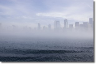
Weather Topic: What is Fog?
Home - Education - Cloud Types - Fog
 Next Topic: Fractus Clouds
Fog is technically a type of stratus cloud, which lies along the
ground and obscures visibility.
It is usually created when humidity in the air condenses into tiny water droplets.
Because of this, some places are more prone to foggy weather, such as regions
close to a body of water.
Fog is similar to mist; both are the appearance of water droplets suspended in
the air, but fog is the term applied to the condition when visibility is less than 1 km.
Next Topic: Fractus Clouds
Weather Topic: What is Freezing Rain?
Home - Education - Precipitation - Freezing Rain
 Next Topic: Graupel
Freezing rain is a condition where precipitation which has fallen in the form of
water droplets reaches temperatures which are below freezing and freezes upon
coming into contact
with surface objects. The result of this precipitation is a glaze of ice which
can be damaging to plants and man-made structures. A severe onset of freezing
rain which results in a very thick glaze of ice is known as an ice storm.
Next Topic: Graupel
Current conditions powered by WeatherAPI.com


