Weather Alert in Minnesota
Winter Storm Warning issued February 16 at 1:23PM CST until February 19 at 12:00PM CST by NWS Duluth MN
AREAS AFFECTED: Central St. Louis; Carlton/South St. Louis
DESCRIPTION: * WHAT...Heavy snow with light ice accumulations expected. Total snow accumulations between 5 and 8 inches except between 8 and 11 inches for the higher terrain northeast of Duluth. Ice accumulations around one tenth of an inch. East winds gusting as high as 55 mph. * WHERE...Carlton and South and Central St. Louis Counties. This includes the Tribal Lands of the Fond du Lac Band and the Bois Forte Band, Lake Vermilion area. * WHEN...From 6 PM Tuesday to noon CST Thursday. * IMPACTS...The strong winds and weight of snow on tree limbs may down power lines and could cause sporadic power outages. Travel could be very difficult. The hazardous conditions could impact the Wednesday morning and evening commutes. * ADDITIONAL DETAILS...The strongest winds are expected Tuesday evening through Wednesday morning from the east off Lake Superior. Near whiteout conditions are possible for a few hour period late Tuesday night as high snowfall rates could combine with those peak winds gusting to 55 mph.
INSTRUCTION: If you must travel, keep an extra flashlight, food, and water in your vehicle in case of an emergency. Call 511 or visit www.511mn.org for Minnesota road information. Do not touch downed lines and report any power outages to your electric company. Slick roadways and the possibility of downed trees and power lines may create hazardous travel conditions.
Want more detail? Get the Complete 7 Day and Night Detailed Forecast!
Current U.S. National Radar--Current
The Current National Weather Radar is shown below with a UTC Time (subtract 5 hours from UTC to get Eastern Time).

National Weather Forecast--Current
The Current National Weather Forecast and National Weather Map are shown below.

National Weather Forecast for Tomorrow
Tomorrow National Weather Forecast and Tomorrow National Weather Map are show below.

North America Water Vapor (Moisture)
This map shows recent moisture content over North America. Bright and colored areas show high moisture (ie, clouds); brown indicates very little moisture present; black indicates no moisture.

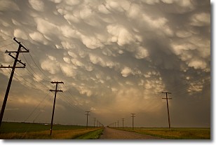
Weather Topic: What are Mammatus Clouds?
Home - Education - Cloud Types - Mammatus Clouds
 Next Topic: Nimbostratus Clouds
A mammatus cloud is a cloud with a unique feature which resembles
a web of pouches hanging along the base of the cloud.
In the United States, mammatus clouds tend to form in the warmer months, commonly
in the Midwest and eastern regions.
While they usually form at the bottom of a cumulonimbis cloud, they can also form
under altostratus, altocumulus, stratocumulus, and cirrus clouds. Mammatus clouds
warn that severe weather is close.
Next Topic: Nimbostratus Clouds
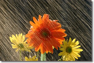
Weather Topic: What is Precipitation?
Home - Education - Precipitation - Precipitation
 Next Topic: Rain
Precipitation can refer to many different forms of water that
may fall from clouds. Precipitation occurs after a cloud has become saturated to
the point where its water particles are more dense than the air below the cloud.
In most cases, precipitation will reach the ground, but it is not uncommon for
precipitation to evaporate before it reaches the earth's surface.
When precipitation evaporates before it contacts the ground it is called Virga.
Graupel, hail, sleet, rain, drizzle, and snow are forms of precipitation, but fog
and mist are not considered precipitation because the water vapor which
constitutes them isn't dense enough to fall to the ground.
Next Topic: Rain
Current conditions powered by WeatherAPI.com


