Weather Alert in North Carolina
Flood Advisory issued May 13 at 11:14AM EDT until May 13 at 6:00PM EDT by NWS Greenville-Spartanburg SC
AREAS AFFECTED: Henderson, NC
DESCRIPTION: * WHAT...Nuisance flooding caused by excessive runoff is lingering. * WHERE...A portion of western North Carolina, including the following county, Henderson. * WHEN...Until 600 PM EDT Tuesday. * IMPACTS...Nuisance flooding of low-lying areas adjacent to streams and other poor-drainage areas, including farmland, parks, greenways, boat-access areas, golf courses, underpasses, and parking lots. Isolated, shallow flows over roadways is possible. A few flood-prone, low-water crossings may become impassible. * ADDITIONAL DETAILS... - At 1104 AM EDT, Elevated runoff continued to work its way through the Mud Creek drainage basin resulting in ongoing nuisance flooding of flood-prone, low-lying areas adjacent to impacted streams. The Mud Creek stage at North Main St was 12.3 feet and will continue to slowly fall through the afternoon with the creek returning to within it's banks by early evening. - Some locations that may continue to experience nuisance flooding include... Hendersonville, Flat Rock, Mountain Home, Laurel Park, Valley Hill, East Flat Rock, Crab Creek and Dana. - Http://www.weather.gov/safety/flood
INSTRUCTION: Be aware of your surroundings and do not drive on flooded roads.
Want more detail? Get the Complete 7 Day and Night Detailed Forecast!
Current U.S. National Radar--Current
The Current National Weather Radar is shown below with a UTC Time (subtract 5 hours from UTC to get Eastern Time).

National Weather Forecast--Current
The Current National Weather Forecast and National Weather Map are shown below.

National Weather Forecast for Tomorrow
Tomorrow National Weather Forecast and Tomorrow National Weather Map are show below.

North America Water Vapor (Moisture)
This map shows recent moisture content over North America. Bright and colored areas show high moisture (ie, clouds); brown indicates very little moisture present; black indicates no moisture.

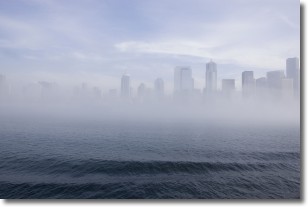
Weather Topic: What is Fog?
Home - Education - Cloud Types - Fog
 Next Topic: Fractus Clouds
Fog is technically a type of stratus cloud, which lies along the
ground and obscures visibility.
It is usually created when humidity in the air condenses into tiny water droplets.
Because of this, some places are more prone to foggy weather, such as regions
close to a body of water.
Fog is similar to mist; both are the appearance of water droplets suspended in
the air, but fog is the term applied to the condition when visibility is less than 1 km.
Next Topic: Fractus Clouds
Weather Topic: What is Freezing Rain?
Home - Education - Precipitation - Freezing Rain
 Next Topic: Graupel
Freezing rain is a condition where precipitation which has fallen in the form of
water droplets reaches temperatures which are below freezing and freezes upon
coming into contact
with surface objects. The result of this precipitation is a glaze of ice which
can be damaging to plants and man-made structures. A severe onset of freezing
rain which results in a very thick glaze of ice is known as an ice storm.
Next Topic: Graupel
Current conditions powered by WeatherAPI.com


