Weather Alert in Idaho
Air Quality Alert issued August 22 at 2:20PM PDT by NWS Spokane WA
AREAS AFFECTED: Latah, ID; Lewis, ID; Nez Perce, ID
DESCRIPTION: An Air Quality Alert has been issued by the following agencies: Idaho Department of Environmental Quality in Lewiston Nez Perce Tribe ERWM Air Quality Program * WHAT...Air Quality Advisory due to smoke from wildfires. Air Quality Index is forecast to be Unhealthy. * WHERE...Latah and Nez Perce Counties, and the Nez Perce Reservation. * WHEN...Until Monday morning August 25th. * IMPACTS...Those who experience health effects from smoke include children under 18, elders, pregnant women, people with asthma or have difficulty breathing, diabetes, heart problems or otherwise compromised health, and people who have high exposure (those who work, exercise, or spend extensive time outdoors).
INSTRUCTION: Under the most severe pollution level, sensitive groups should avoid outdoor exposure and limit indoor activities, and everyone should restrict their outdoor activities. Idaho Department of Health and Welfare https://healthandwelfare.idaho.gov/health-wellness/environmental- health/idaho-wildfire-and-smoke-information Idaho Smoke Information Hotline: 1-800-345-1007 Idaho DEQ Lewiston Regional Office - (208)-799-4370
Want more detail? Get the Complete 7 Day and Night Detailed Forecast!
Current U.S. National Radar--Current
The Current National Weather Radar is shown below with a UTC Time (subtract 5 hours from UTC to get Eastern Time).

National Weather Forecast--Current
The Current National Weather Forecast and National Weather Map are shown below.

National Weather Forecast for Tomorrow
Tomorrow National Weather Forecast and Tomorrow National Weather Map are show below.

North America Water Vapor (Moisture)
This map shows recent moisture content over North America. Bright and colored areas show high moisture (ie, clouds); brown indicates very little moisture present; black indicates no moisture.

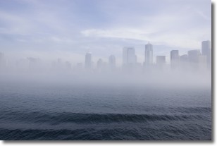
Weather Topic: What is Fog?
Home - Education - Cloud Types - Fog
 Next Topic: Fractus Clouds
Fog is technically a type of stratus cloud, which lies along the
ground and obscures visibility.
It is usually created when humidity in the air condenses into tiny water droplets.
Because of this, some places are more prone to foggy weather, such as regions
close to a body of water.
Fog is similar to mist; both are the appearance of water droplets suspended in
the air, but fog is the term applied to the condition when visibility is less than 1 km.
Next Topic: Fractus Clouds
Weather Topic: What is Freezing Rain?
Home - Education - Precipitation - Freezing Rain
 Next Topic: Graupel
Freezing rain is a condition where precipitation which has fallen in the form of
water droplets reaches temperatures which are below freezing and freezes upon
coming into contact
with surface objects. The result of this precipitation is a glaze of ice which
can be damaging to plants and man-made structures. A severe onset of freezing
rain which results in a very thick glaze of ice is known as an ice storm.
Next Topic: Graupel
Current conditions powered by WeatherAPI.com


