Weather Alert in North Carolina
Flood Watch issued May 13 at 7:24AM EDT until May 14 at 2:00AM EDT by NWS Wakefield VA
AREAS AFFECTED: Northampton; Hertford; Gates; Bertie; Chowan; Perquimans; Fluvanna; Prince Edward; Cumberland; Goochland; Mecklenburg; Lunenburg; Nottoway; Amelia; Powhatan; Brunswick; Dinwiddie; Prince George; Greensville; Sussex; Southampton; Western Louisa; Eastern Louisa; Western Hanover; Western Chesterfield; Eastern Chesterfield (Including Col. Heights); Western Henrico (Including the City of Richmond); Eastern Henrico
DESCRIPTION: * WHAT...Flooding caused by excessive rainfall continues to be possible. * WHERE...Portions of northeast North Carolina, including the following areas, Bertie, Chowan, Gates, Hertford, Northampton and Perquimans and Virginia, including the following areas, Amelia, Brunswick, Cumberland, Dinwiddie, Eastern Chesterfield (Including Col. Heights), Eastern Henrico, Eastern Louisa, Fluvanna, Goochland, Greensville, Lunenburg, Mecklenburg, Nottoway, Powhatan, Prince Edward, Prince George, Southampton, Sussex, Western Chesterfield, Western Hanover, Western Henrico (Including the City of Richmond) and Western Louisa. * WHEN...Through late tonight. * IMPACTS...Excessive runoff may result in flooding of rivers, creeks, streams, and other low-lying and flood-prone locations. * ADDITIONAL DETAILS... - A prolonged period of showers with a few embedded thunderstorms will lead to rainfall totals between 1-3" with locally higher amounts in heavier banding of showers and thunderstorms through late tonight. - http://www.weather.gov/safety/flood
INSTRUCTION: You should monitor later forecasts and be alert for possible Flood Warnings. Those living in areas prone to flooding should be prepared to take action should flooding develop.
Want more detail? Get the Complete 7 Day and Night Detailed Forecast!
Current U.S. National Radar--Current
The Current National Weather Radar is shown below with a UTC Time (subtract 5 hours from UTC to get Eastern Time).

National Weather Forecast--Current
The Current National Weather Forecast and National Weather Map are shown below.

National Weather Forecast for Tomorrow
Tomorrow National Weather Forecast and Tomorrow National Weather Map are show below.

North America Water Vapor (Moisture)
This map shows recent moisture content over North America. Bright and colored areas show high moisture (ie, clouds); brown indicates very little moisture present; black indicates no moisture.

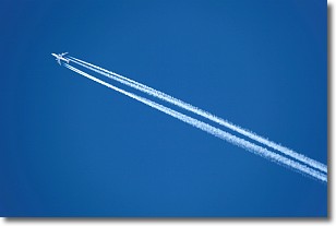
Weather Topic: What are Contrails?
Home - Education - Cloud Types - Contrails
 Next Topic: Cumulonimbus Clouds
A contrail is an artificial cloud, created by the passing of an
aircraft.
Contrails form because water vapor in the exhaust of aircraft engines is suspended
in the air under certain temperatures and humidity conditions. These contrails
are called exhaust contrails.
Another type of contrail can form due to a temporary reduction in air pressure
moving over the plane's surface, causing condensation.
These are called aerodynamic contrails.
When you can see your breath on a cold day, it is also because of condensation.
The reason contrails last longer than the condensation from your breath is
because the water in contrails freezes into ice particles.
Next Topic: Cumulonimbus Clouds
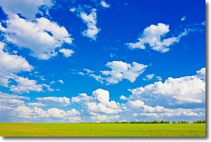
Weather Topic: What are Cumulus Clouds?
Home - Education - Cloud Types - Cumulus Clouds
 Next Topic: Drizzle
Cumulus clouds are fluffy and textured with rounded tops, and
may have flat bottoms. The border of a cumulus cloud
is clearly defined, and can have the appearance of cotton or cauliflower.
Cumulus clouds form at low altitudes (rarely above 2 km) but can grow very tall,
becoming cumulus congestus and possibly the even taller cumulonimbus clouds.
When cumulus clouds become taller, they have a greater chance of producing precipitation.
Next Topic: Drizzle
Current conditions powered by WeatherAPI.com


