Weather Alert in Arizona
Dust Storm Warning issued June 30 at 6:37PM MST until June 30 at 8:00PM MST by NWS Tucson AZ
AREAS AFFECTED: Cochise, AZ
DESCRIPTION: The National Weather Service in Tucson has issued a * Dust Storm Warning for... South Central Cochise County in southeastern Arizona... * Until 800 PM MST. * At 637 PM MST, an area of blowing dust was located 18 miles southeast of Pearce-Sunsites, moving south at 15 mph. HAZARD...Less than a quarter mile visibility. SOURCE...Detected by National Weather Service meteorologists. IMPACT...Dangerous life-threatening travel. * Locations impacted include... Douglas, Bisbee, Naco, Bisbee-Douglas Airport, Pearce-Sunsites, Pirtleville, Elfrida, Sunizona and McNeal. This includes the following highways... Route 90 near mile marker 336. Route 80 between mile markers 321 and 322...and between mile markers 328 and 372. Route 181 near mile marker 41. Route 191 between mile markers 1 and 38. Route 92 between mile markers 345 and 355.
INSTRUCTION: Motorists should not drive into a dust storm. PULL ASIDE STAY ALIVE! Dust storms lead to dangerous driving conditions with visibility reduced to near zero. If driving, avoid dust storms if possible. If caught in one, pull off the road, turn off your lights and keep your foot off the brake.
Want more detail? Get the Complete 7 Day and Night Detailed Forecast!
Current U.S. National Radar--Current
The Current National Weather Radar is shown below with a UTC Time (subtract 5 hours from UTC to get Eastern Time).

National Weather Forecast--Current
The Current National Weather Forecast and National Weather Map are shown below.

National Weather Forecast for Tomorrow
Tomorrow National Weather Forecast and Tomorrow National Weather Map are show below.

North America Water Vapor (Moisture)
This map shows recent moisture content over North America. Bright and colored areas show high moisture (ie, clouds); brown indicates very little moisture present; black indicates no moisture.

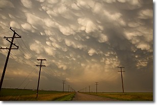
Weather Topic: What are Mammatus Clouds?
Home - Education - Cloud Types - Mammatus Clouds
 Next Topic: Nimbostratus Clouds
A mammatus cloud is a cloud with a unique feature which resembles
a web of pouches hanging along the base of the cloud.
In the United States, mammatus clouds tend to form in the warmer months, commonly
in the Midwest and eastern regions.
While they usually form at the bottom of a cumulonimbis cloud, they can also form
under altostratus, altocumulus, stratocumulus, and cirrus clouds. Mammatus clouds
warn that severe weather is close.
Next Topic: Nimbostratus Clouds
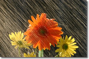
Weather Topic: What is Precipitation?
Home - Education - Precipitation - Precipitation
 Next Topic: Rain
Precipitation can refer to many different forms of water that
may fall from clouds. Precipitation occurs after a cloud has become saturated to
the point where its water particles are more dense than the air below the cloud.
In most cases, precipitation will reach the ground, but it is not uncommon for
precipitation to evaporate before it reaches the earth's surface.
When precipitation evaporates before it contacts the ground it is called Virga.
Graupel, hail, sleet, rain, drizzle, and snow are forms of precipitation, but fog
and mist are not considered precipitation because the water vapor which
constitutes them isn't dense enough to fall to the ground.
Next Topic: Rain
Current conditions powered by WeatherAPI.com


