Weather Alert in Oregon
Extreme Heat Warning issued August 22 at 12:23PM PDT until August 27 at 9:00PM PDT by NWS Pendleton OR
AREAS AFFECTED: Eastern Columbia River Gorge of Oregon; Lower Columbia Basin of Oregon; Foothills of the Northern Blue Mountains of Oregon; Foothills of the Southern Blue Mountains of Oregon; North Central Oregon; Eastern Columbia River Gorge of Washington; Kittitas Valley; Yakima Valley; Lower Columbia Basin of Washington; Foothills of the Blue Mountains of Washington; Simcoe Highlands; Lower Slopes of the Eastern Washington Cascades Crest
DESCRIPTION: * WHAT...Dangerously hot conditions with temperatures up to 98 to 104 degrees expected. This will pose a major to locally extreme risk of heat-related illness. * WHERE...Portions of north central and northeast Oregon and central, south central, and southeast Washington. * WHEN...From noon Saturday to 9 PM PDT Wednesday. * IMPACTS...Heat related illnesses increase significantly during extreme heat events. * ADDITIONAL DETAILS...An alternative scenario is lingering cloud cover from possible thunderstorms from southern Oregon may result in lower than forecast afternoon temperatures or higher than forecast overnight low temperatures.
INSTRUCTION: Drink plenty of fluids, stay in an air-conditioned room, stay out of the sun, and check up on relatives and neighbors. Young children and pets should never be left unattended in vehicles under any circumstances. Take extra precautions if you work or spend time outside. When possible reschedule strenuous activities to early morning or evening. Know the signs and symptoms of heat exhaustion and heat stroke. Wear lightweight and loose fitting clothing when possible. To reduce risk during outdoor work, the Occupational Safety and Health Administration recommends scheduling frequent rest breaks in shaded or air conditioned environments. Anyone overcome by heat should be moved to a cool and shaded location. Heat stroke is an emergency! Call 9 1 1. For sheltering information and other human services in your area, dial 2 1 1 during business hours or visit 211info.org for Oregon or wa211.org for Washington anytime.
Want more detail? Get the Complete 7 Day and Night Detailed Forecast!
Current U.S. National Radar--Current
The Current National Weather Radar is shown below with a UTC Time (subtract 5 hours from UTC to get Eastern Time).

National Weather Forecast--Current
The Current National Weather Forecast and National Weather Map are shown below.

National Weather Forecast for Tomorrow
Tomorrow National Weather Forecast and Tomorrow National Weather Map are show below.

North America Water Vapor (Moisture)
This map shows recent moisture content over North America. Bright and colored areas show high moisture (ie, clouds); brown indicates very little moisture present; black indicates no moisture.

Weather Topic: What is Hail?
Home - Education - Precipitation - Hail
 Next Topic: Hole Punch Clouds
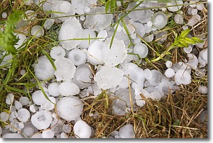
Hail is a form of precipitation which is recognized by large solid balls or
clumps of ice. Hail is created by thunderstorm clouds with strong updrafts of wind.
As the hailstones remain in the updraft, ice is deposited onto them until their
weight becomes heavy enough for them to fall to the earth's surface.
Hail storms can cause significant damage to crops, aircrafts, and man-made structures,
despite the fact that the duration is usually less than ten minutes.
Next Topic: Hole Punch Clouds
Weather Topic: What are Mammatus Clouds?
Home - Education - Cloud Types - Mammatus Clouds
 Next Topic: Nimbostratus Clouds
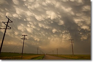
A mammatus cloud is a cloud with a unique feature which resembles
a web of pouches hanging along the base of the cloud.
In the United States, mammatus clouds tend to form in the warmer months, commonly
in the Midwest and eastern regions.
While they usually form at the bottom of a cumulonimbis cloud, they can also form
under altostratus, altocumulus, stratocumulus, and cirrus clouds. Mammatus clouds
warn that severe weather is close.
Next Topic: Nimbostratus Clouds
Current conditions powered by WeatherAPI.com


