Weather Alert in Idaho
Heat Advisory issued August 23 at 2:13PM PDT until August 27 at 9:00PM PDT by NWS Spokane WA
AREAS AFFECTED: Coeur d'Alene Area; Idaho Palouse; Lewis and Southern Nez Perce Counties; Northeast Blue Mountains; Washington Palouse; Spokane Area; Northeast Mountains; Okanogan Highlands
DESCRIPTION: * WHAT...Hot temperatures. High temperatures 90 to 99 degrees for elevations below 3500 feet. High temperatures 80 to 89 degrees for elevations above 3500 feet. Limited overnight relief with low temperatures 57 to 65. * WHERE...Moscow, Plummer, Fruitland, Oakesdale, La Crosse, Tekoa, Kettle Falls, Wauconda, Deer Park, Boulder Creek Road, Newport, Uniontown, Rockford, Downtown Spokane, Northport, Metaline, Rosalia, Potlatch, Craigmont, Colville, Inchelium, Nezperce, Coeur d'Alene, Mountain Road, Airway Heights, Metaline Falls, Genesee, Spokane Valley, Chewelah, Tiger, Springdale-Hunters Road, Colfax, Hayden, Pullman, Flowery Trail Road, Winchester, Peola, Fairfield, Cheney, Anatone, Republic, Soldiers Meadow Road, Sherman Pass, Highway 20 Wauconda Summit, Ione, Kamiah, Chesaw Road, Orin-Rice Road, Worley, Post Falls, Cloverland Road, and Davenport. * WHEN...Until 9 PM PDT Wednesday. * IMPACTS...Hot temperatures will increase the risk of heat-related illnesses. Heat of this magnitude affects anyone without cooling and hydration as well as health systems and industries.
INSTRUCTION: Drink plenty of fluids, stay in an air-conditioned room, stay out of the sun, and check up on relatives and neighbors. Take extra precautions when outside. Wear lightweight and loose fitting clothing. Try to limit strenuous activities to early morning or evening. Take action when you see symptoms of heat exhaustion and heat stroke. To reduce risk during outdoor work, the Occupational Safety and Health Administration recommends scheduling frequent rest breaks in shaded or air conditioned environments. Anyone overcome by heat should be moved to a cool and shaded location. Heat stroke is an emergency! Call 9 1 1.
Want more detail? Get the Complete 7 Day and Night Detailed Forecast!
Current U.S. National Radar--Current
The Current National Weather Radar is shown below with a UTC Time (subtract 5 hours from UTC to get Eastern Time).

National Weather Forecast--Current
The Current National Weather Forecast and National Weather Map are shown below.

National Weather Forecast for Tomorrow
Tomorrow National Weather Forecast and Tomorrow National Weather Map are show below.

North America Water Vapor (Moisture)
This map shows recent moisture content over North America. Bright and colored areas show high moisture (ie, clouds); brown indicates very little moisture present; black indicates no moisture.

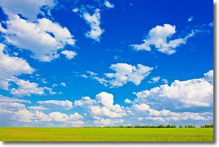
Weather Topic: What are Cumulus Clouds?
Home - Education - Cloud Types - Cumulus Clouds
 Next Topic: Drizzle
Cumulus clouds are fluffy and textured with rounded tops, and
may have flat bottoms. The border of a cumulus cloud
is clearly defined, and can have the appearance of cotton or cauliflower.
Cumulus clouds form at low altitudes (rarely above 2 km) but can grow very tall,
becoming cumulus congestus and possibly the even taller cumulonimbus clouds.
When cumulus clouds become taller, they have a greater chance of producing precipitation.
Next Topic: Drizzle
Weather Topic: What is Evaporation?
Home - Education - Precipitation - Evaporation
 Next Topic: Fog
Evaporation is the process which returns water from the earth
back to the atmosphere, and is another crucial process in the water cycle.
Evaporation is the transformation of liquid into gas, and it happens because
molecules are excited by the application of energy and turn into vapor.
In order for water to evaporate it has to be on the surface of a body of water.
Next Topic: Fog
Current conditions powered by WeatherAPI.com


