Weather Alert in Indiana
Flood Warning issued March 4 at 10:51PM EST until March 9 at 12:00AM EDT by NWS Indianapolis IN
AREAS AFFECTED: Bartholomew, IN; Johnson, IN; Shelby, IN
DESCRIPTION: ...The Flood Warning is extended for the following rivers in Indiana... Buck Creek at Acton. Flatrock River at Saint Paul. East Fork White River at Columbus. ...The Flood Warning continues for the following rivers in Indiana... Flatrock River near Columbus. Driftwood River near Edinburgh. Big Blue River at Shelbyville. Eel River at Bowling Green. East Fork White River at Seymour. Clifty Creek at Hartsville. .Between 2 and 4 inches of rain have fallen across central Indiana as of early Wednesday morning. Up to 2 inches have fallen in south-central Indiana. This has led creeks to rise above flood stage and rivers will follow in the coming days. Additional rain is in the forecast over the next several days. * WHAT...Minor flooding is occurring and moderate flooding is forecast. * WHERE...Driftwood River near Edinburgh. * WHEN...Until early Monday morning. * IMPACTS...At 14.9 feet, Extensive flooding along Driftwood River in northern Bartholomew County on March 7, 2011. Double Y Saddle Club area extensively flooded. Water flowing over CR 950N to Club. CR 330W is flooded just south of its intersection with Ohio Ridge Rd. CR 500N west of CR 250W is flooded blocking vehicular access to residences near the river bank. Lowell Public Access site is completely flooded. Water very near several residences and seasonal homes along CR 330W and CR 325W. * ADDITIONAL DETAILS... - At 9:30 PM EST Wednesday the stage was 12.6 feet. - Recent Activity...The maximum river stage in the 24 hours ending at 9:30 PM EST Wednesday was 12.6 feet. - Forecast...The river is expected to rise to a crest of 14.7 feet tomorrow evening. It will then fall below flood stage early Sunday afternoon. - Flood stage is 11.0 feet. - http://www.weather.gov/safety/flood
INSTRUCTION: Motorists should not attempt to drive around barricades or drive cars through flooded areas. Additional information is available at www.weather.gov/ind. The next statement should be issued Thursday afternoon by around 145 PM EST.
Want more detail? Get the Complete 7 Day and Night Detailed Forecast!
Current U.S. National Radar--Current
The Current National Weather Radar is shown below with a UTC Time (subtract 5 hours from UTC to get Eastern Time).

National Weather Forecast--Current
The Current National Weather Forecast and National Weather Map are shown below.

National Weather Forecast for Tomorrow
Tomorrow National Weather Forecast and Tomorrow National Weather Map are show below.

North America Water Vapor (Moisture)
This map shows recent moisture content over North America. Bright and colored areas show high moisture (ie, clouds); brown indicates very little moisture present; black indicates no moisture.

Weather Topic: What is Drizzle?
Home - Education - Precipitation - Drizzle
 Next Topic: Evaporation
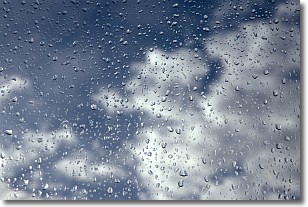
Drizzle is precipitation in the form of water droplets which are
smaller than raindrops.
Drizzle is characterized by fine, gently falling droplets and typically does not
impact human habitation in a negative way. The exception to this is freezing drizzle,
a condition where drizzle freezes immediately upon reaching earth's surface.
Freezing drizzle is still less dangerous than freezing rain, but can
potentially result in hazardous road conditions.
Next Topic: Evaporation
Weather Topic: What is Fog?
Home - Education - Cloud Types - Fog
 Next Topic: Fractus Clouds
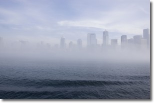
Fog is technically a type of stratus cloud, which lies along the
ground and obscures visibility.
It is usually created when humidity in the air condenses into tiny water droplets.
Because of this, some places are more prone to foggy weather, such as regions
close to a body of water.
Fog is similar to mist; both are the appearance of water droplets suspended in
the air, but fog is the term applied to the condition when visibility is less than 1 km.
Next Topic: Fractus Clouds
Current conditions powered by WeatherAPI.com


