Weather Alert in California
Avalanche Warning issued February 17 at 5:19AM PST by NWS Reno NV
AREAS AFFECTED: Greater Lake Tahoe Area; Greater Lake Tahoe Area
DESCRIPTION: AVWREV The following message is transmitted at the request of the U.S. Forest Service Sierra Avalanche Center. The Sierra Avalanche Center in Truckee has issued a BACKCOUNTRY AVALANCHE WARNING for the following areas: NWS Reno NV - NVZ002 (Greater Lake Tahoe)...CAZ072 (Greater Lake Tahoe (CA)) * WHAT...HIGH avalanche danger exists in the backcountry. Large avalanches are expected to occur Tuesday, Tuesday night, and into at least early Wednesday morning across backcountry terrain. HIGH avalanche danger might continue through the day on Wednesday. * WHERE...Central Sierra Nevada Mountains between Yuba Pass (Highway 49) on the north and Ebbetts Pass (Highway 4) on the south, including the greater Lake Tahoe area. This does not include ski areas or highways where avalanche mitigation programs exist. * WHEN...In effect from Tuesday 5 AM PST to Wednesday 5 AM PST. * IMPACTS...Rapidly accumulating snowfall, weak layers in the existing snowpack, and gale-force winds that blow and drift snow have created dangerous avalanche conditions in the mountains. Natural avalanches are likely, and human-triggered avalanches large enough to bury or injure people are very likely. * PRECAUTIONARY / PREPAREDNESS ACTIONS...Traveling in, near, or below backcountry avalanche terrain is not recommended during HIGH avalanche danger. Consult https://www.sierraavalanchecenter.org/ or www.avalanche.org for more detailed information. Similar avalanche danger may exist at locations outside the coverage area of this or any avalanche center.
INSTRUCTION: N/A
Want more detail? Get the Complete 7 Day and Night Detailed Forecast!
Current U.S. National Radar--Current
The Current National Weather Radar is shown below with a UTC Time (subtract 5 hours from UTC to get Eastern Time).

National Weather Forecast--Current
The Current National Weather Forecast and National Weather Map are shown below.

National Weather Forecast for Tomorrow
Tomorrow National Weather Forecast and Tomorrow National Weather Map are show below.

North America Water Vapor (Moisture)
This map shows recent moisture content over North America. Bright and colored areas show high moisture (ie, clouds); brown indicates very little moisture present; black indicates no moisture.

Weather Topic: What are Altostratus Clouds?
Home - Education - Cloud Types - Altostratus Clouds
 Next Topic: Cirrocumulus Clouds
Altostratus clouds form at mid to high-level altitudes
(between 2 and 7 km) and are created by a warm, stable air mass which causes
water vapor
to condense as it rise through the atmosphere. Usually altostratus clouds are
featureless sheets characterized by a uniform color.
In some cases, wind punching through the cloud formation may give it a waved
appearance, called altostratus undulatus. Altostratus clouds
are commonly seen with other cloud formations accompanying them.
Next Topic: Cirrocumulus Clouds
Weather Topic: What are Cirrostratus Clouds?
Home - Education - Cloud Types - Cirrostratus Clouds
 Next Topic: Cirrus Clouds
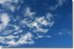
Cirrostratus clouds are high, thin clouds that form above
20,000 feet and are made mostly of ice crystals. They sometimes look like giant
feathers, horse tails, or curls of hair in the sky.
These clouds are pushed by the jet stream and can move at high speeds reaching
100 mph.
What do they indicate?
They indicate that a precipitation is likely within 24 hours.
Next Topic: Cirrus Clouds
Current conditions powered by WeatherAPI.com


