Weather Alert in New York
Coastal Flood Watch issued February 20 at 4:27PM EST until February 23 at 5:00AM EST by NWS Upton NY
AREAS AFFECTED: Bronx; Northwest Suffolk; Northern Queens; Northern Nassau
DESCRIPTION: * WHAT...1 1/2 to 2 1/2 ft of inundation above ground level possible in vulnerable areas near the waterfront and shoreline. * WHERE...Bronx, Northwest Suffolk, Northern Queens and Northern Nassau Counties. * WHEN...Late Sunday night. * COASTAL FLOOD IMPACTS...Widespread moderate flooding of vulnerable areas near the waterfront and shoreline possible. 1 1/2 to 2 1/2 ft of inundation above ground level possible in low lying, vulnerable areas. This would result in numerous road closures and cause widespread flooding of low lying property including parking lots, parks, lawns and homes/businesses with basements near the waterfront. Vehicles parked in vulnerable areas near the waterfront will likely become flooded. Flooding will also extend inland from the waterfront along tidal rivers and bays. Ice cover in the bays and harbors could exacerbate flooding and cause damage to northeast to east facing shoreline structure. * SHORELINE IMPACTS...Breaking surf of 3 to 5 ft along north and east facing shorelines will cause beach flooding and dune erosion during the time of high tide. This may also exacerbate splashover flooding of shorelines roads and properties behind protective dunes, structures and seawalls. Minor damage to shoreline structures possible. * ADDITIONAL DETAILS...This water level forecast will be highly dependent on timing of windshift from east northeast to north gales with respect to the time of high tide, and will be refined over the next 24 hours. Ice cover in the bays and harbors could exacerbate flooding and cause damage to northeast to east facing shoreline structure.
INSTRUCTION: If travel is required, allow extra time as some roads may be closed. Do not drive around barricades or through water of unknown depth. Take the necessary actions to protect flood-prone property.
Want more detail? Get the Complete 7 Day and Night Detailed Forecast!
Current U.S. National Radar--Current
The Current National Weather Radar is shown below with a UTC Time (subtract 5 hours from UTC to get Eastern Time).

National Weather Forecast--Current
The Current National Weather Forecast and National Weather Map are shown below.

National Weather Forecast for Tomorrow
Tomorrow National Weather Forecast and Tomorrow National Weather Map are show below.

North America Water Vapor (Moisture)
This map shows recent moisture content over North America. Bright and colored areas show high moisture (ie, clouds); brown indicates very little moisture present; black indicates no moisture.

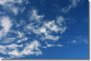
Weather Topic: What are Cirrostratus Clouds?
Home - Education - Cloud Types - Cirrostratus Clouds
 Next Topic: Cirrus Clouds
Cirrostratus clouds are high, thin clouds that form above
20,000 feet and are made mostly of ice crystals. They sometimes look like giant
feathers, horse tails, or curls of hair in the sky.
These clouds are pushed by the jet stream and can move at high speeds reaching
100 mph.
What do they indicate?
They indicate that a precipitation is likely within 24 hours.
Next Topic: Cirrus Clouds
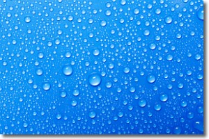
Weather Topic: What is Condensation?
Home - Education - Precipitation - Condensation
 Next Topic: Contrails
Condensation is the process which creates clouds, and therefore
it is a crucial process in the water cycle.
Condensation is the change of matter from a state of gas into a state of liquid,
and it happens because water molecules release heat into the atmosphere and
become organized into a more closely packed structure, what we might see as
water droplets.
Water is always present in the air around us as a vapor, but it's too small for
us to see. When water undergoes the process of condensation it becomes organized
into visible water droplets. You've probably seen condensation happen before on the
surface of a cold drink!
Next Topic: Contrails
Current conditions powered by WeatherAPI.com


