Weather Alert in Wisconsin
Winter Weather Advisory issued February 17 at 1:58AM CST until February 19 at 6:00PM CST by NWS Duluth MN
AREAS AFFECTED: Ashland; Iron
DESCRIPTION: * WHAT...Mixed precipitation expected. Total snow accumulations up to 3 inches and ice accumulations around one tenth of an inch. Winds gusting as high as 35 mph. * WHERE...Ashland and Iron Counties. This includes the Tribal Lands of the northwestern area of the Lac du Flambeau Band and the Bad River Reservation. Other locations including Madeline Island. * WHEN...From 6 PM this evening to 6 PM CST Thursday. * IMPACTS...Plan on slippery road conditions. The hazardous conditions could impact the Wednesday morning and evening commutes. * ADDITIONAL DETAILS...Snow is favored for the northern half of the county while ice is more likely for the southern half.
INSTRUCTION: Slow down and use caution while traveling. Call 511 or visit www.511wi.gov for Wisconsin road information.
Want more detail? Get the Complete 7 Day and Night Detailed Forecast!
Current U.S. National Radar--Current
The Current National Weather Radar is shown below with a UTC Time (subtract 5 hours from UTC to get Eastern Time).

National Weather Forecast--Current
The Current National Weather Forecast and National Weather Map are shown below.

National Weather Forecast for Tomorrow
Tomorrow National Weather Forecast and Tomorrow National Weather Map are show below.

North America Water Vapor (Moisture)
This map shows recent moisture content over North America. Bright and colored areas show high moisture (ie, clouds); brown indicates very little moisture present; black indicates no moisture.

Weather Topic: What is Freezing Rain?
Home - Education - Precipitation - Freezing Rain
 Next Topic: Graupel
Freezing rain is a condition where precipitation which has fallen in the form of
water droplets reaches temperatures which are below freezing and freezes upon
coming into contact
with surface objects. The result of this precipitation is a glaze of ice which
can be damaging to plants and man-made structures. A severe onset of freezing
rain which results in a very thick glaze of ice is known as an ice storm.
Next Topic: Graupel
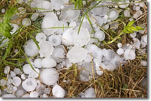
Weather Topic: What is Hail?
Home - Education - Precipitation - Hail
 Next Topic: Hole Punch Clouds
Hail is a form of precipitation which is recognized by large solid balls or
clumps of ice. Hail is created by thunderstorm clouds with strong updrafts of wind.
As the hailstones remain in the updraft, ice is deposited onto them until their
weight becomes heavy enough for them to fall to the earth's surface.
Hail storms can cause significant damage to crops, aircrafts, and man-made structures,
despite the fact that the duration is usually less than ten minutes.
Next Topic: Hole Punch Clouds
Current conditions powered by WeatherAPI.com


