Weather Alert in Indiana
Flood Warning issued April 1 at 2:34PM EDT until April 9 at 12:00AM EDT by NWS Indianapolis IN
AREAS AFFECTED: Parke, IN; Vermillion, IN; Vigo, IN
DESCRIPTION: ...The National Weather Service in Indianapolis IN has issued a Flood Warning for the following rivers in Indiana... Wabash River at Montezuma. Wabash River at Lafayette. Wabash River at Covington. .Multiple rounds of rainfall will bring minor lowland flooding to the Wabash River basin over the next couple of days that could hang around through much of next week. * WHAT...Minor flooding is forecast. * WHERE...Wabash River at Montezuma. * WHEN...From Thursday morning to Thursday, April 09. * IMPACTS...At 20.0 feet, Park in southern Montezuma begins to flood. Higher bottomlands begin to flood. Water backs up most local tributaries. River water is at the top of some private levees. Lowest county roads begin to flood. Parke CR 75 W begins to flood. * ADDITIONAL DETAILS... - At 1:45 PM EDT Wednesday the stage was 7.9 feet. - Forecast...The river is expected to rise above flood stage tomorrow morning to a crest of 20.7 feet Saturday evening. It will then fall below flood stage Wednesday, April 08. - Flood stage is 14.0 feet. - http://www.weather.gov/safety/flood
INSTRUCTION: Motorists should not attempt to drive around barricades or drive cars through flooded areas. Additional information is available at www.weather.gov/ind. The next statement should be issued Thursday afternoon by around 1230 PM EDT.
Want more detail? Get the Complete 7 Day and Night Detailed Forecast!
Current U.S. National Radar--Current
The Current National Weather Radar is shown below with a UTC Time (subtract 5 hours from UTC to get Eastern Time).

National Weather Forecast--Current
The Current National Weather Forecast and National Weather Map are shown below.

National Weather Forecast for Tomorrow
Tomorrow National Weather Forecast and Tomorrow National Weather Map are show below.

North America Water Vapor (Moisture)
This map shows recent moisture content over North America. Bright and colored areas show high moisture (ie, clouds); brown indicates very little moisture present; black indicates no moisture.

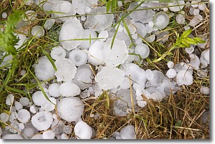
Weather Topic: What is Hail?
Home - Education - Precipitation - Hail
 Next Topic: Hole Punch Clouds
Hail is a form of precipitation which is recognized by large solid balls or
clumps of ice. Hail is created by thunderstorm clouds with strong updrafts of wind.
As the hailstones remain in the updraft, ice is deposited onto them until their
weight becomes heavy enough for them to fall to the earth's surface.
Hail storms can cause significant damage to crops, aircrafts, and man-made structures,
despite the fact that the duration is usually less than ten minutes.
Next Topic: Hole Punch Clouds
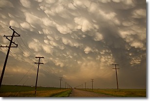
Weather Topic: What are Mammatus Clouds?
Home - Education - Cloud Types - Mammatus Clouds
 Next Topic: Nimbostratus Clouds
A mammatus cloud is a cloud with a unique feature which resembles
a web of pouches hanging along the base of the cloud.
In the United States, mammatus clouds tend to form in the warmer months, commonly
in the Midwest and eastern regions.
While they usually form at the bottom of a cumulonimbis cloud, they can also form
under altostratus, altocumulus, stratocumulus, and cirrus clouds. Mammatus clouds
warn that severe weather is close.
Next Topic: Nimbostratus Clouds
Current conditions powered by WeatherAPI.com


