Weather Alert in California
Fire Weather Watch issued June 30 at 1:41AM PDT until July 1 at 8:00PM PDT by NWS Medford OR
AREAS AFFECTED: Western Klamath National Forest; Central Siskiyou County Including Shasta Valley; Siskiyou County from the Cascade Mountains East and South to Mt Shasta
DESCRIPTION: ...RED FLAG WARNING IN EFFECT FROM 2 PM TO 8 PM PDT MONDAY FOR FOR ABUNDANT LIGHTNING ON DRY FUELS FOR FIRE WEATHER ZONES 280, 281, AND 284... ...FIRE WEATHER WATCH IN EFFECT FROM TUESDAY AFTERNOON THROUGH TUESDAY EVENING FOR FOR ABUNDANT LIGHTNING ON DRY FUELS FOR FIRE WEATHER ZONES 280, 281, AND 284... The National Weather Service in Medford has upgraded the Fire Weather Watch to a Red Flag Warning, which is in effect from 2 PM to 8 PM PDT Monday. Another Fire Weather Watch has also been issued. This Fire Weather Watch is in effect from Tuesday afternoon through Tuesday evening. * IMPACTS...Given the long stretch of dry and hot and very conditions, lightning efficiency will be high to very high for fire starts. Any fires that develop will likely spread rapidly. * AFFECTED AREA...All of Fire Weather Zones 280, 281, and 284. * THUNDERSTORMS...Isolated to scattered thunderstorms. Lightning strikes outside of precipitation cores are possible, and cause for concern. * OUTFLOW WINDS...Gust up to 35 mph. These outflow winds can travel up to 50 miles away from the thunderstorm that caused it. * ADDITIONAL INFORMATION...Storms will tend to be isolated to start then increasing during the afternoon into the early evening hours both Monday and Tuesday. Thunderstorms are expected to trend wetter later in the afternoon and early evening both Monday and Tuesday, but remain a mix of wet and dry storms. * DETAILED URL...View the hazard area in detail at https://www.wrh.noaa.gov/map/?wfo=mfr
INSTRUCTION: Follow all fire restrictions. You can find your county's emergency sign up form as well as links to fire restrictions at weather.gov/medford/wildfire. One less spark, one less wildfire. Be sure you're signed up for your county's emergency alert system. Familiarize yourself with your emergency plan and make sure you listen to emergency services. Visit ready.gov/plan for more information. A Red Flag Warning is issued when we identify weather conditions that promote rapid spread of fire which may become life- threatening. This does not mean there is a fire. These conditions are either occurring now or will begin soon. It is important to have multiple ways to receive information from authorities. Follow all fire restrictions. Avoid activities that could cause sparks. Visit weather.gov/medford/wildfire for links to fire restrictions in your area. If you have not packet your go kit yet, now is the time to do so. This includes items like important documents and essentials you cannot live without. Fill your vehicle's fuel tank. Visit ready.gov/kit for more information. A Fire Weather Watch means that critical fire weather conditions are possible during the valid watch time. These conditions could promote the rapid spread of wildfires which could become life- threatening. Check weather.gov/medford for forecast updates and a possible upgrade of the this watch to a Red Flag Warning.
Want more detail? Get the Complete 7 Day and Night Detailed Forecast!
Current U.S. National Radar--Current
The Current National Weather Radar is shown below with a UTC Time (subtract 5 hours from UTC to get Eastern Time).

National Weather Forecast--Current
The Current National Weather Forecast and National Weather Map are shown below.

National Weather Forecast for Tomorrow
Tomorrow National Weather Forecast and Tomorrow National Weather Map are show below.

North America Water Vapor (Moisture)
This map shows recent moisture content over North America. Bright and colored areas show high moisture (ie, clouds); brown indicates very little moisture present; black indicates no moisture.

Weather Topic: What are Altostratus Clouds?
Home - Education - Cloud Types - Altostratus Clouds
 Next Topic: Cirrocumulus Clouds
Altostratus clouds form at mid to high-level altitudes
(between 2 and 7 km) and are created by a warm, stable air mass which causes
water vapor
to condense as it rise through the atmosphere. Usually altostratus clouds are
featureless sheets characterized by a uniform color.
In some cases, wind punching through the cloud formation may give it a waved
appearance, called altostratus undulatus. Altostratus clouds
are commonly seen with other cloud formations accompanying them.
Next Topic: Cirrocumulus Clouds
Weather Topic: What are Cirrostratus Clouds?
Home - Education - Cloud Types - Cirrostratus Clouds
 Next Topic: Cirrus Clouds
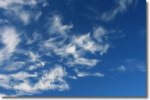
Cirrostratus clouds are high, thin clouds that form above
20,000 feet and are made mostly of ice crystals. They sometimes look like giant
feathers, horse tails, or curls of hair in the sky.
These clouds are pushed by the jet stream and can move at high speeds reaching
100 mph.
What do they indicate?
They indicate that a precipitation is likely within 24 hours.
Next Topic: Cirrus Clouds
Current conditions powered by WeatherAPI.com


