Weather Alert in Alaska
Winter Weather Advisory issued February 16 at 6:30PM AKST until February 18 at 3:00PM AKST by NWS Fairbanks AK
AREAS AFFECTED: Lower Koyukuk Valley; Middle Yukon Valley
DESCRIPTION: * WHAT...Snow and blowing snow. Total snow accumulations between 4 and 7 inches possible. Winds could gust as high as 30 mph. * WHERE...Lower Koyukuk Valley, Lower Yukon and Innoko Valleys, Middle Yukon Valley, North Slopes of the Western Alaska Range, and Upper Kuskokwim Valley. * WHEN...From 3 AM Tuesday to 3 PM AKST Wednesday. * IMPACTS...Travel could be very difficult. * ADDITIONAL DETAILS...Some blowing snow is possible and visibility may approach one-half mile at times.
INSTRUCTION: Slow down and use caution while traveling.
Want more detail? Get the Complete 7 Day and Night Detailed Forecast!
Current U.S. National Radar--Current
The Current National Weather Radar is shown below with a UTC Time (subtract 5 hours from UTC to get Eastern Time).

National Weather Forecast--Current
The Current National Weather Forecast and National Weather Map are shown below.

National Weather Forecast for Tomorrow
Tomorrow National Weather Forecast and Tomorrow National Weather Map are show below.

North America Water Vapor (Moisture)
This map shows recent moisture content over North America. Bright and colored areas show high moisture (ie, clouds); brown indicates very little moisture present; black indicates no moisture.

Weather Topic: What is Fog?
Home - Education - Cloud Types - Fog
 Next Topic: Fractus Clouds
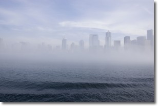
Fog is technically a type of stratus cloud, which lies along the
ground and obscures visibility.
It is usually created when humidity in the air condenses into tiny water droplets.
Because of this, some places are more prone to foggy weather, such as regions
close to a body of water.
Fog is similar to mist; both are the appearance of water droplets suspended in
the air, but fog is the term applied to the condition when visibility is less than 1 km.
Next Topic: Fractus Clouds
Weather Topic: What is Freezing Rain?
Home - Education - Precipitation - Freezing Rain
 Next Topic: Graupel
Freezing rain is a condition where precipitation which has fallen in the form of
water droplets reaches temperatures which are below freezing and freezes upon
coming into contact
with surface objects. The result of this precipitation is a glaze of ice which
can be damaging to plants and man-made structures. A severe onset of freezing
rain which results in a very thick glaze of ice is known as an ice storm.
Next Topic: Graupel
Current conditions powered by WeatherAPI.com


