Weather Alert in Colorado
Flash Flood Warning issued September 7 at 5:50PM MDT until September 7 at 7:45PM MDT by NWS Grand Junction CO
AREAS AFFECTED: Rio Blanco, CO
DESCRIPTION: FFWGJT The National Weather Service in Grand Junction has issued a * Flash Flood Warning for... The Lee Burn Scar in... Central Rio Blanco County in northwestern Colorado... * Until 745 PM MDT. * At 550 PM MDT, Doppler radar indicated thunderstorms producing heavy rain over the Lee Burn Scar. Flash flooding is ongoing or expected to begin shortly. Excessive rainfall over the burn scar will result in debris flow. The debris flow can consist of rock, mud, vegetation and other loose materials. HAZARD...Flash flooding. Thunderstorms producing flash flooding in and around the Lee Burn Scar. SOURCE...Radar. IMPACT...Flash flooding of areas in and around the Lee Burn Scar. * Some locations that will experience flash flooding include... mainly rural areas of Central Rio Blanco County
INSTRUCTION: Heavy rainfall will cause extensive and severe flash flooding of creeks...streams...and ditches in the Lee Burn Scar. Severe debris flows can also be anticipated across roads. Roads and driveways may be washed away in places. If you encounter flood waters...climb to safety. Move away from recently burned areas. Flooding of creeks, roads and normally dry arroyos is likely. The heavy rains will likely trigger rockslides, mudslides and debris flows in steep terrain, especially in and around these areas. Please report observed flooding to local emergency services or law enforcement and request they pass this information to the National Weather Service when you can do so safely.
Want more detail? Get the Complete 7 Day and Night Detailed Forecast!
Current U.S. National Radar--Current
The Current National Weather Radar is shown below with a UTC Time (subtract 5 hours from UTC to get Eastern Time).

National Weather Forecast--Current
The Current National Weather Forecast and National Weather Map are shown below.

National Weather Forecast for Tomorrow
Tomorrow National Weather Forecast and Tomorrow National Weather Map are show below.

North America Water Vapor (Moisture)
This map shows recent moisture content over North America. Bright and colored areas show high moisture (ie, clouds); brown indicates very little moisture present; black indicates no moisture.

Weather Topic: What are Fractus Clouds?
Home - Education - Cloud Types - Fractus Clouds
 Next Topic: Freezing Rain
A fractus cloud (scud) is a fragmented, tattered cloud which has
likely been sheared off of another cloud. They are accessory clouds, meaning they
develop from parent clouds, and are named in a way which describes the original
cloud which contained them.
Fractus clouds which have originated from cumulus clouds are referred to as
cumulus fractus, while fractus clouds which have originated from stratus clouds
are referred to as stratus fractus. Under certain conditions a fractus cloud might
merge with another cloud, or develop into a cumulus cloud, but usually a
fractus cloud seen by itself will dissipate rapidly.
They are often observed on the leading and trailing edges of storm clouds,
and are a display of wind activity.
Next Topic: Freezing Rain
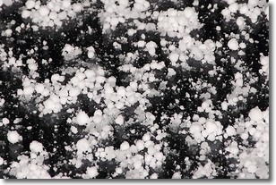
Weather Topic: What is Graupel?
Home - Education - Precipitation - Graupel
 Next Topic: Hail
Graupel is a form of precipitation that is created by atmospheric conditions
which cause supercooled water droplets to contact snow crystals and freeze to
their surface.
Sometimes known as soft hail or snow pellets, graupel is delicate and easily
destroyed by touch. Whereas hail usually falls during severe weather, graupel
doesn't require such conditions to form, and can form in mild precipitation
similar to situations which produce snowfall.
Next Topic: Hail
Current conditions powered by WeatherAPI.com


