Weather Alert in Georgia
Red Flag Warning issued February 23 at 11:42AM EST until February 23 at 7:00PM EST by NWS Peachtree City GA
AREAS AFFECTED: Heard; Troup; Meriwether; Upson; Harris; Talbot; Taylor; Crawford; Muscogee; Chattahoochee; Marion; Schley; Macon; Peach; Houston; Stewart; Webster; Sumter; Dooly; Crisp; Pulaski; Wilcox; Dodge; Telfair; Wheeler; Montgomery; Toombs
DESCRIPTION: The National Weather Service in Peachtree City has issued a Red Flag Warning for gusty winds, low relative humidity, and dry fuels, which is in effect until 7 PM EST this evening. * Affected Area... South and east central Georgia. * Timing... This afternoon through early evening. * Winds... Northwest at 10 to 15 mph with gusts up to 25 mph. * Relative Humidity... Falling below 25 percent by early afternoon. * Temperatures... 40s. * Impacts... With elevated winds and low relative humidities, critical fire weather conditions are possible. Outdoor burning is strongly discouraged.
INSTRUCTION: This warning includes the Oconee National Forest. A Red Flag Warning means that critical fire weather conditions are either occurring...or will occur within 24 hours. Please refer to the local burn permitting authorities on whether you may burn outdoors. If you do burn outside...use extreme caution. Please advise the appropriate officials or fire crews in the field of the Red Flag Warning.
Want more detail? Get the Complete 7 Day and Night Detailed Forecast!
Current U.S. National Radar--Current
The Current National Weather Radar is shown below with a UTC Time (subtract 5 hours from UTC to get Eastern Time).

National Weather Forecast--Current
The Current National Weather Forecast and National Weather Map are shown below.

National Weather Forecast for Tomorrow
Tomorrow National Weather Forecast and Tomorrow National Weather Map are show below.

North America Water Vapor (Moisture)
This map shows recent moisture content over North America. Bright and colored areas show high moisture (ie, clouds); brown indicates very little moisture present; black indicates no moisture.

Weather Topic: What is Sleet?
Home - Education - Precipitation - Sleet
 Next Topic: Snow
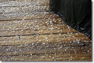
Sleet is a form of precipitation in which small ice pellets are the primary
components. These ice pellets are smaller and more translucent than hailstones,
and harder than graupel. Sleet is caused by specific atmospheric conditions and
therefore typically doesn't last for extended periods of time.
The condition which leads to sleet formation requires a warmer body of air to be
wedged in between two sub-freezing bodies of air. When snow falls through a warmer
layer of air it melts, and as it falls through the next sub-freezing body of air
it freezes again, forming ice pellets known as sleet. In some cases, water
droplets don't have time to freeze before reaching the surface and the result is
freezing rain.
Next Topic: Snow
Weather Topic: What are Stratocumulus Clouds?
Home - Education - Cloud Types - Stratocumulus Clouds
 Next Topic: Stratus Clouds
Stratocumulus clouds are similar to altocumulus clouds in their
fluffy appearance, but have a slightly darker shade due to their additional mass.
A good way to distinguish the two cloud types is to hold your hand out and measure
the size of an individual cloud; if it is the size of your thumb it is generally
an altocumulus cloud, if it is the size of your hand it is generally a
stratocumulus cloud.
It is uncommon for stratocumulus clouds to produce precipitation, but if they do
it is usually a light rain or snow.
Next Topic: Stratus Clouds
Current conditions powered by WeatherAPI.com


