Weather Alert in California
Flash Flood Warning issued September 10 at 3:25PM PDT until September 10 at 6:00PM PDT by NWS Sacramento CA
AREAS AFFECTED: Tehama, CA
DESCRIPTION: At 325 PM PDT, Doppler radar indicated thunderstorms producing heavy rain over the Tehama County Division of the Park Fire Burn Scar. The expected rainfall rate is 0.5 to 1 inch in 1 hour. Flash flooding is ongoing or expected to begin shortly. Excessive rainfall over the warning area will cause mud slides near steep terrain. The mud slide can consist of rock, mud, vegetation and other loose materials. HAZARD...Life threatening flash flooding. Thunderstorms producing flash flooding in and around the Tehama County Division of the Park Fire Burn Scar. SOURCE...Radar. IMPACT...Life threatening flash flooding of areas in and around the Tehama County Division of the Park Fire Burn Scar. Some locations that will experience flash flooding include... Mineral, Paynes Creek and Manton. * Additional locations include... Highway 36 corridor, Paynes Creek, Mill Creek, Deer Creek, and Pine Creek
INSTRUCTION: Move away from recently burned areas. Life-threatening flooding of creeks, roads and normally dry areas is likely. The heavy rains will likely trigger rockslides, mudslides and debris flows in steep terrain, especially in and around these areas. Turn around, don't drown when encountering flooded roads. Most flood deaths occur in vehicles. This is a life threatening situation. Heavy rainfall will cause extensive and severe flash flooding of creeks...streams...and ditches in the Tehama County Division of the Park Fire Burn Scar. Severe debris flows can also be anticipated across roads. Roads and driveways may be washed away in places. If you encounter flood waters...climb to safety.
Want more detail? Get the Complete 7 Day and Night Detailed Forecast!
Current U.S. National Radar--Current
The Current National Weather Radar is shown below with a UTC Time (subtract 5 hours from UTC to get Eastern Time).

National Weather Forecast--Current
The Current National Weather Forecast and National Weather Map are shown below.

National Weather Forecast for Tomorrow
Tomorrow National Weather Forecast and Tomorrow National Weather Map are show below.

North America Water Vapor (Moisture)
This map shows recent moisture content over North America. Bright and colored areas show high moisture (ie, clouds); brown indicates very little moisture present; black indicates no moisture.

Weather Topic: What is Freezing Rain?
Home - Education - Precipitation - Freezing Rain
 Next Topic: Graupel
Freezing rain is a condition where precipitation which has fallen in the form of
water droplets reaches temperatures which are below freezing and freezes upon
coming into contact
with surface objects. The result of this precipitation is a glaze of ice which
can be damaging to plants and man-made structures. A severe onset of freezing
rain which results in a very thick glaze of ice is known as an ice storm.
Next Topic: Graupel
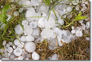
Weather Topic: What is Hail?
Home - Education - Precipitation - Hail
 Next Topic: Hole Punch Clouds
Hail is a form of precipitation which is recognized by large solid balls or
clumps of ice. Hail is created by thunderstorm clouds with strong updrafts of wind.
As the hailstones remain in the updraft, ice is deposited onto them until their
weight becomes heavy enough for them to fall to the earth's surface.
Hail storms can cause significant damage to crops, aircrafts, and man-made structures,
despite the fact that the duration is usually less than ten minutes.
Next Topic: Hole Punch Clouds
Current conditions powered by WeatherAPI.com


